IMAGES TAKEN NEAR TO
East Sutton Park, MAIDSTONE, ME17 3DF
Introduction
This page details the photographs taken nearby to East Sutton Park, ME17 3DF by members of the Geograph project.
The Geograph project started in 2005 with the aim of publishing, organising and preserving representative images for every square kilometre of Great Britain, Ireland and the Isle of Man.

There are currently over 7.5m images from over14,400 individuals and you can help contribute to the project by visiting https://www.geograph.org.uk
Image Map
Images are licensed for reuse under creativecommons.org/licenses/by-sa/2.0
Notes
- Clicking on the map will re-center to the selected point.
- The higher the marker number, the further away the image location is from the centre of the postcode.
Image Listing (57 Images Found)
Images are licensed for reuse under creativecommons.org/licenses/by-sa/2.0
Image
Details
Distance

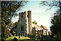
7
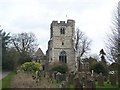
East Sutton Church (2)
On Church Lane, seen from small war memorial and graveyard on north side of the road.
Image: © David Anstiss
Taken: 26 Feb 2009
0.08 miles
8
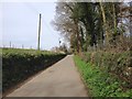
Junction of Workhouse Rd and Church Lane
Image: © N Chadwick
Taken: 25 Nov 2012
0.08 miles
9
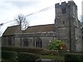
St. Peter & St. Paul Church, East Sutton
Image: © Roger Smith
Taken: 15 May 1996
0.08 miles