IMAGES TAKEN NEAR TO
Lower Road, MAIDSTONE, ME17 3BH
Introduction
This page details the photographs taken nearby to Lower Road, ME17 3BH by members of the Geograph project.
The Geograph project started in 2005 with the aim of publishing, organising and preserving representative images for every square kilometre of Great Britain, Ireland and the Isle of Man.

There are currently over 7.5m images from over14,400 individuals and you can help contribute to the project by visiting https://www.geograph.org.uk
Image Map
Images are licensed for reuse under creativecommons.org/licenses/by-sa/2.0
Notes
- Clicking on the map will re-center to the selected point.
- The higher the marker number, the further away the image location is from the centre of the postcode.
Image Listing (201 Images Found)
Images are licensed for reuse under creativecommons.org/licenses/by-sa/2.0
Image
Details
Distance
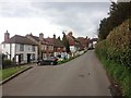
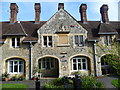
2
![Sutton Valence houses [4]](https://s0.geograph.org.uk/geophotos/07/07/84/7078492_d99de35f_120x120.jpg)
Sutton Valence houses [4]
Valence Green Cottage. Lower Road, was built in the early 19th century, Timber framed and weatherboarded, under a tile roof. Listed, grade II, with details at: https://historicengland.org.uk/listing/the-list/list-entry/1060871
Sutton Valence is a village 5¼ miles southeast of Maidstone and about 13 miles northwest of Ashford. The area was settled in the Iron Age and a Roman road passes through. Known as Sutton until the manor became the property of William de Valence, The village is home to a castle, now ruinous, built in the late 12th century and one of the oldest schools in England, founded in 1576 as a Free Grammar School.
Image: © Michael Dibb
Taken: 11 Sep 2021
0.02 miles
3
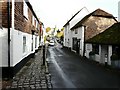
Broad Street, Sutton Valence
The building's wall nearest to the camera has been smartened up since I last photographed this view in 1969 see http://www.geograph.org.uk/photo/1708599
Image: © John Baker
Taken: 31 Oct 2010
0.02 miles
4
![Sutton Valence houses [5]](https://s3.geograph.org.uk/geophotos/07/07/84/7078495_145ff158_120x120.jpg)
Sutton Valence houses [5]
Spring Cottages. Lower Road, were, according to the plaque, built by J Higgins in 1854. Constructed of red and yellow brick under a replacement pantile roof.
Sutton Valence is a village 5¼ miles southeast of Maidstone and about 13 miles northwest of Ashford. The area was settled in the Iron Age and a Roman road passes through. Known as Sutton until the manor became the property of William de Valence, The village is home to a castle, now ruinous, built in the late 12th century and one of the oldest schools in England, founded in 1576 as a Free Grammar School.
Image: © Michael Dibb
Taken: 11 Sep 2021
0.02 miles
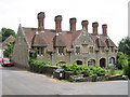
7
![Sutton Valence houses [3]](https://s2.geograph.org.uk/geophotos/07/07/84/7078478_8776003b_120x120.jpg)
Sutton Valence houses [3]
These six almshouses, Holdgate House, South Lane, were built in 1888 to replace the almshouses in High Street Image which became part of Sutton Valence School. Constructed of rubble stone with ashlar dressings under a tile roof. Holdgate House is now part of the school.
Sutton Valence is a village 5¼ miles southeast of Maidstone and about 13 miles northwest of Ashford. The area was settled in the Iron Age and a Roman road passes through. Known as Sutton until the manor became the property of William de Valence, The village is home to a castle, now ruinous, built in the late 12th century and one of the oldest schools in England, founded in 1576 as a Free Grammar School.
Image: © Michael Dibb
Taken: 11 Sep 2021
0.03 miles
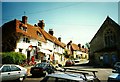
8
The Lambe Almshouses, Sutton Valence
The plaque in the centre below the coat of arms says 'IN 1568 WILLIAM LAMBE CITIZEN AND CLOTHWORKER OF LONDON FOUNDED AND ERECTED SIX ALMSHOUSES ADJOINING HIS GRAMMAR SCHOOL IN THIS VILLAGE. IN 1888 THE WORSHIPFUL COMPANY OF CLOTHWORKERS HIS TRUSTEES RE-ERECTED THEM ON THIS SITE.' The later date of 1888 appears above the coat of arms.
Image: © Marathon
Taken: 27 Sep 2013
0.03 miles
9

Lambe's Almshouses
Two of a row of 6 almshouses founded by William Lambe in 1574 http://www.geograph.org.uk/photo/1013040 restored after a fire in 1909-10, now part of Sutton Valence School.
Image: © Richard Croft
Taken: 18 Aug 2008
0.03 miles
10
![Sutton Valence buildings [4]](https://s2.geograph.org.uk/geophotos/07/07/92/7079274_033a056a_120x120.jpg)
Sutton Valence buildings [4]
This row of former almshouses in High Street are now part of Sutton Valence School. They were endowed in 1574 by William Lambe, a year or two before he founded the School, and were in use as almshouses until they were replaced in the 1880s by the new almshouses, Holdgate House, in South Lane Image Constructed of coursed stone under a tile roof, they were restored in 1910 following a fire. Listed, grade II, with details at: https://historicengland.org.uk/listing/the-list/list-entry/1060910
Sutton Valence is a village 5¼ miles southeast of Maidstone and about 13 miles northwest of Ashford. The area was settled in the Iron Age and a Roman road passes through. Known as Sutton until the manor became the property of William de Valence, The village is home to a castle, now ruinous, built in the late 12th century and one of the oldest schools in England, founded in 1576 as a Free Grammar School.
Image: © Michael Dibb
Taken: 11 Sep 2021
0.03 miles