IMAGES TAKEN NEAR TO
Lower Road, MAIDSTONE, ME17 3AL
Introduction
This page details the photographs taken nearby to Lower Road, ME17 3AL by members of the Geograph project.
The Geograph project started in 2005 with the aim of publishing, organising and preserving representative images for every square kilometre of Great Britain, Ireland and the Isle of Man.

There are currently over 7.5m images from over14,400 individuals and you can help contribute to the project by visiting https://www.geograph.org.uk
Image Map (Loading...)


Getting Data...Please wait
Leaflet Map data © OpenStreetMap
Images are licensed for reuse under creativecommons.org/licenses/by-sa/2.0
Notes
- Clicking on the map will re-center to the selected point.
- The higher the marker number, the further away the image location is from the centre of the postcode.
Image Listing (186 Images Found)
Images are licensed for reuse under creativecommons.org/licenses/by-sa/2.0
Image
Details
Distance
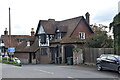
2
![Sutton Valence houses [11]](https://s0.geograph.org.uk/geophotos/07/07/92/7079224_dc17d3d0_120x120.jpg)
Sutton Valence houses [11]
This large building in Lower Road, once one dwelling, is now subdivided into three. Ivy House Image, Old Place Image, and Longwall, seen here. Built in the 15th or early 16th century, with late 16th or early 17th century alterations. There were further extensive alterations and extensions circa 1900 and again circa 1930. Timber framed, mainly clad with chequered red and grey brick, the ground floor of the left wing is of coursed galletted stone. The remainder is exposed close-studding with plaster infilling, all under a tile roof. Listed, grade II, with details at: https://historicengland.org.uk/listing/the-list/list-entry/1367117
Sutton Valence is a village 5¼ miles southeast of Maidstone and about 13 miles northwest of Ashford. The area was settled in the Iron Age and a Roman road passes through. Known as Sutton until the manor became the property of William de Valence, The village is home to a castle, now ruinous, built in the late 12th century and one of the oldest schools in England, founded in 1576 as a Free Grammar School.
Image: © Michael Dibb
Taken: 11 Sep 2021
0.00 miles
3
![Sutton Valence houses [9]](https://s2.geograph.org.uk/geophotos/07/07/92/7079222_16f11e0a_120x120.jpg)
Sutton Valence houses [9]
This large building in Lower Road, once one dwelling, is now subdivided into three. Ivy House, seen here, Old Place, Image, and Longwall Image Built in the 15th or early 16th century, with late 16th or early 17th century alterations. There were further extensive alterations and extensions circa 1900 and again circa 1930. Timber framed, mainly clad with chequered red and grey brick, the ground floor of the left wing is of coursed galletted stone. The remainder is exposed close-studding with plaster infilling, all under a tile roof. Listed, grade II, with details at: https://historicengland.org.uk/listing/the-list/list-entry/1367117
Sutton Valence is a village 5¼ miles southeast of Maidstone and about 13 miles northwest of Ashford. The area was settled in the Iron Age and a Roman road passes through. Known as Sutton until the manor became the property of William de Valence, The village is home to a castle, now ruinous, built in the late 12th century and one of the oldest schools in England, founded in 1576 as a Free Grammar School.
Image: © Michael Dibb
Taken: 11 Sep 2021
0.01 miles
4
![Sutton Valence houses [10]](https://s3.geograph.org.uk/geophotos/07/07/92/7079223_8ae2959e_120x120.jpg)
Sutton Valence houses [10]
This large building in Lower Road, once one dwelling, is now subdivided into three. Ivy House Image, Old Place, seen here, and Longwall Image Built in the 15th or early 16th century, with late 16th or early 17th century alterations. There were further extensive alterations and extensions circa 1900 and again circa 1930. Timber framed, mainly clad with chequered red and grey brick, the ground floor of the left wing is of coursed galletted stone. The remainder is exposed close-studding with plaster infilling, all under a tile roof. Listed, grade II, with details at: https://historicengland.org.uk/listing/the-list/list-entry/1367117
Sutton Valence is a village 5¼ miles southeast of Maidstone and about 13 miles northwest of Ashford. The area was settled in the Iron Age and a Roman road passes through. Known as Sutton until the manor became the property of William de Valence, The village is home to a castle, now ruinous, built in the late 12th century and one of the oldest schools in England, founded in 1576 as a Free Grammar School.
Image: © Michael Dibb
Taken: 11 Sep 2021
0.01 miles
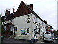
6
![Sutton Valence buildings [3]](https://s1.geograph.org.uk/geophotos/07/07/92/7079269_5bdf14d4_120x120.jpg)
Sutton Valence buildings [3]
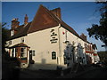
The Queen's Head public house was built in the 17th century and refaced in the mid or late 19th century. Timber framed with the front in rendered brick or stone, all under a tile roof. Some original internal features remain. Listed, grade II, with details at: https://historicengland.org.uk/listing/the-list/list-entry/1372286
Sutton Valence is a village 5¼ miles southeast of Maidstone and about 13 miles northwest of Ashford. The area was settled in the Iron Age and a Roman road passes through. Known as Sutton until the manor became the property of William de Valence, The village is home to a castle, now ruinous, built in the late 12th century and one of the oldest schools in England, founded in 1576 as a Free Grammar School.
Image: © Michael Dibb
Taken: 11 Sep 2021
0.01 miles
8
![Sutton Valence features [1]](https://s1.geograph.org.uk/geophotos/07/07/92/7079225_28e4b02e_120x120.jpg)
Sutton Valence features [1]
A Victorian letter box in the wall in Lower Road.
Sutton Valence is a village 5¼ miles southeast of Maidstone and about 13 miles northwest of Ashford. The area was settled in the Iron Age and a Roman road passes through. Known as Sutton until the manor became the property of William de Valence, The village is home to a castle, now ruinous, built in the late 12th century and one of the oldest schools in England, founded in 1576 as a Free Grammar School.
Image: © Michael Dibb
Taken: 11 Sep 2021
0.02 miles
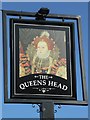
10
The Queens Head, Sutton Valence
Greene King pub on High Street.
Also see Image
Image: © Oast House Archive
Taken: 19 Nov 2010
0.02 miles