IMAGES TAKEN NEAR TO
Groom Way, MAIDSTONE, ME17 2QQ
Introduction
This page details the photographs taken nearby to Groom Way, ME17 2QQ by members of the Geograph project.
The Geograph project started in 2005 with the aim of publishing, organising and preserving representative images for every square kilometre of Great Britain, Ireland and the Isle of Man.

There are currently over 7.5m images from over14,400 individuals and you can help contribute to the project by visiting https://www.geograph.org.uk
Image Map
Images are licensed for reuse under creativecommons.org/licenses/by-sa/2.0
Notes
- Clicking on the map will re-center to the selected point.
- The higher the marker number, the further away the image location is from the centre of the postcode.
Image Listing (171 Images Found)
Images are licensed for reuse under creativecommons.org/licenses/by-sa/2.0
Image
Details
Distance
1
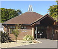
Lenham Community Centre
Built and opened at the turn of the century. The white lantern feature at the top of the roof is shaped to imitate the weathervane vents on Kentish oast houses. In this case it doesn't move. Photo taken from the public right of way which passes through the car park.
Image: © Mike Sharpe
Taken: 24 Sep 2009
0.03 miles
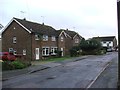
2
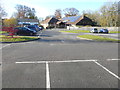
Lenham Community Centre
Accessed from Old Ashford Road via Groom Way.
Image: © John Baker
Taken: 19 Nov 2017
0.04 miles
4
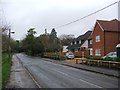
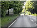
Footpath crosses A20 Ashford Road
Leads from North Downs Way (long distance path) over busy road (many lorries) into Lenham village.
Image: © David Anstiss
Taken: 22 Feb 2009
0.07 miles
9
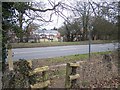
War Memorial in Lenham Cemetery
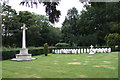
This War Memorial is in the cemetery adjacent to the busy A20. The gravestones to the side are 46 R.E.M.E. 6th Guards Tank Brigade workshop personnel stationed between Lenham and Charing killed by a flying bomb on 24 June 1944. However, the smaller cross contains the names of all 52 killed in this incident (see supplementary photograph). A small plaque appears on the left-hand pillar gates to the cemetery.
Also in the cemetery are 36 Canadian war graves from WWI probably from the wartime Canadian Hospital that was located nearby.
Image: © Dave Skinner
Taken: 14 Sep 2007
0.10 miles
10
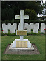
War Memorial Lenham Cemetery
This small cross contains the names of all 52 R.E.M.E personnel killed by a flying bomb on 24 June 1944.
Image: © Dave Skinner
Taken: 14 Sep 2007
0.11 miles