IMAGES TAKEN NEAR TO
Croft Gardens, MAIDSTONE, ME17 2QE
Introduction
This page details the photographs taken nearby to Croft Gardens, ME17 2QE by members of the Geograph project.
The Geograph project started in 2005 with the aim of publishing, organising and preserving representative images for every square kilometre of Great Britain, Ireland and the Isle of Man.

There are currently over 7.5m images from over14,400 individuals and you can help contribute to the project by visiting https://www.geograph.org.uk
Image Map
Images are licensed for reuse under creativecommons.org/licenses/by-sa/2.0
Notes
- Clicking on the map will re-center to the selected point.
- The higher the marker number, the further away the image location is from the centre of the postcode.
Image Listing (177 Images Found)
Images are licensed for reuse under creativecommons.org/licenses/by-sa/2.0
Image
Details
Distance
3
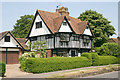
Honywood, High St, Lenham
The house is dated 1621.
Image: © David Kemp
Taken: 5 Jul 2013
0.05 miles
4
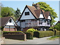
Honywood, High Street, Lenham
Grade II* listed building, dated 1621.
Image: © pam fray
Taken: 21 Apr 2019
0.05 miles
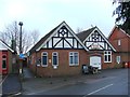
5

Lenham Cricket Club - private ground
Next game: 'No games from 11th to 17th June - Club on tour'. The tour seems to include playing at Selsey, Gosport and Portsmouth.
Image: © Robin Webster
Taken: 9 Jun 2016
0.07 miles
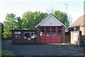
7
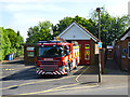
Lenham fire station
Room for just one fire engine.
Image: © Robin Webster
Taken: 9 Jun 2016
0.07 miles
8
Lenham fire station
Lenham fire station, High Street, Lenham, Maidstone, Kent
Image: © Kevin Hale
Taken: 28 Apr 2009
0.08 miles