IMAGES TAKEN NEAR TO
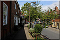
High Street, MAIDSTONE, ME17 2QD
Introduction
This page details the photographs taken nearby to High Street, ME17 2QD by members of the Geograph project.
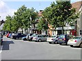
The Geograph project started in 2005 with the aim of publishing, organising and preserving representative images for every square kilometre of Great Britain, Ireland and the Isle of Man.

There are currently over 7.5m images from over14,400 individuals and you can help contribute to the project by visiting https://www.geograph.org.uk
Image Map
Images are licensed for reuse under creativecommons.org/licenses/by-sa/2.0
Notes
- Clicking on the map will re-center to the selected point.
- The higher the marker number, the further away the image location is from the centre of the postcode.
Image Listing (182 Images Found)
Images are licensed for reuse under creativecommons.org/licenses/by-sa/2.0
Image
Details
Distance
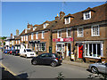
1
Lenham Square
Lenham has many listed buildings including the red Giles Gilbert Scott telephone box.
Image: © Penny Mayes
Taken: 3 Aug 2005
0.00 miles
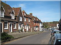
2
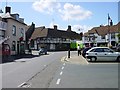
Lenham town centre
The junction of Old Ashford Road (from where the photo was taken), High Street (on the left), Maidstone Road (straight on) and Faversham Road (on the right). All but the High Street lead to the A20 which bypasses the town to the north.
Image: © Penny Mayes
Taken: 3 Aug 2005
0.00 miles
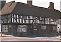
3
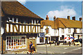
The Square, Lenham
Old half-timbered house and the Red Lion on the western side of the village square.
Image: © Colin Smith
Taken: Unknown
0.00 miles
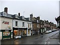
4
Lenham High Street, east side
All of these buildings are grade II listed.
Image: © Robin Webster
Taken: 9 Jun 2016
0.01 miles
7
Lenham village square ? a typical timbered house
Lenham is a most attractive Kent village. It lies in the shadow of an escarpment rising 300 feet to the chalk Downs in the north, and has the source of the Great Stour river to the south watering its cornfields and orchards. “It has one of Kent’s lovely old squares … an ancient market place. A row of limes throws its shadow across the square on which timbered houses and quaint fronted shops look down.” (‘The King’s England’, Arthur Mee). For the history of the parish and its housing http://www.lenham.net/History/History%20of%20Housing%20in%20Lenham%20P2.htm . Also see the Gallery at: http://www.geograph.org.uk/gallery/trail_of_a_kentish_farming_family_9094 (background family story http://books.google.com/books?id=hrpS_YQ9FoAC&printsec=frontcover&dq=On+Kentish+Chalk )
Image: © D Gore
Taken: Unknown
0.03 miles
9

Old Direction Sign - Signpost by High Street, Lenham
No finial - 1 arm; Kent CC wood by the UC road, in parish of Lenham (Maidstone District), High Street immediately South of junction with Maidstone Road, fixed to brick wall of a pharmacy at ground floor level.
To be surveyed
Milestone Society National ID: KE_TQ8952C
Image: © Milestone Society
Taken: Unknown
0.03 miles
10
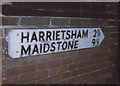
Old Direction Sign - Signpost by Maidstone Road, Lenham parish
No finial - 1 arm; Kent CC wood by the UC road, in parish of Lenham (Maidstone District), Maidstone Road immediately West of junction with High Street, fixed to brick wall of a pharmacy at ground floor level.
Surveyed
Milestone Society National ID: KE_TQ8952A
Image: © Milestone Society
Taken: Unknown
0.04 miles