IMAGES TAKEN NEAR TO
Faversham Road, MAIDSTONE, ME17 2PN
Introduction
This page details the photographs taken nearby to Faversham Road, ME17 2PN by members of the Geograph project.
The Geograph project started in 2005 with the aim of publishing, organising and preserving representative images for every square kilometre of Great Britain, Ireland and the Isle of Man.

There are currently over 7.5m images from over14,400 individuals and you can help contribute to the project by visiting https://www.geograph.org.uk
Image Map
Images are licensed for reuse under creativecommons.org/licenses/by-sa/2.0
Notes
- Clicking on the map will re-center to the selected point.
- The higher the marker number, the further away the image location is from the centre of the postcode.
Image Listing (184 Images Found)
Images are licensed for reuse under creativecommons.org/licenses/by-sa/2.0
Image
Details
Distance
1
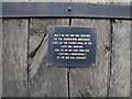
Sign detail, the "Lock up", Lenham
Providing a potted history.
Image: © Chris Whippet
Taken: 21 Sep 2010
0.02 miles
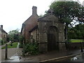
2
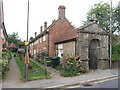
Douglas Court, Lenham
The Douglas almshouses were endowed by J.S. Douglas of the Chilston Estate.
Image: © Chris Whippet
Taken: 21 Sep 2010
0.03 miles
6
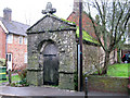
Workhouse mortuary, Lenham
Built as a workhouse mortuary in the mid 18C and then used as the parish gaol - see http://www.geograph.org.uk/photo/2077501
Image: © Nick Smith
Taken: 11 Jan 2011
0.05 miles
7
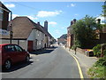
The old workhouse mortuary in Lenham Village
This was built in the mid 18th century as the workhouse mortuary, it was used as the parish jail in the late 19th century, and as a suitably reinforced air raid shelter in the 1940s.
Image: © Marathon
Taken: 7 May 2022
0.05 miles
8
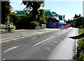
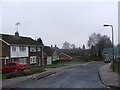
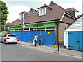
Looking south along Faversham Road
Towards the redevelopment of number 8 for which planning permission has been granted by Maidstone Borough Council under application number 15/501072/FULL for “variation of Condition 20 (code for sustainable homes) of approved planning permission ref 13/1570 for demolition of existing fire-damaged building (class A1 retail use and B1 office use) and the erection of a mixed use development comprising class A1 retail use at ground floor level and 4 two bedroom apartments at first floor level”. This shows the Image
Image: © John Baker
Taken: 9 Aug 2015
0.05 miles
9
The co-operative Lenham, 8, Faversham Road
Compared with Image, although the ground floor of the store is still hidden by hoarding, its name has been added above. Planning permission has been granted by Maidstone Borough Council under application number 15/501072/FULL for a “variation of Condition 20 (code for sustainable homes) of approved planning permission number 13/1570 for demolition of existing fire-damaged building (class A1 retail use and B1 office use) and the erection of a mixed use development comprising class A1 retail use at ground floor level and 4 two bedroom apartments at first floor level”.
Image: © John Baker
Taken: 15 May 2016
0.05 miles
10
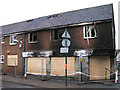
Burnt out premises of Lenham Ironmongers
Several premises were damaged during the fire, see http://www.bbc.co.uk/news/uk-england-kent-11642509
Image: © Nick Smith
Taken: 11 Jan 2011
0.05 miles