IMAGES TAKEN NEAR TO
Liverton Hill, MAIDSTONE, ME17 2NR
Introduction
This page details the photographs taken nearby to Liverton Hill, ME17 2NR by members of the Geograph project.
The Geograph project started in 2005 with the aim of publishing, organising and preserving representative images for every square kilometre of Great Britain, Ireland and the Isle of Man.

There are currently over 7.5m images from over14,400 individuals and you can help contribute to the project by visiting https://www.geograph.org.uk
Image Map
Images are licensed for reuse under creativecommons.org/licenses/by-sa/2.0
Notes
- Clicking on the map will re-center to the selected point.
- The higher the marker number, the further away the image location is from the centre of the postcode.
Image Listing (41 Images Found)
Images are licensed for reuse under creativecommons.org/licenses/by-sa/2.0
Image
Details
Distance
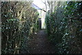
1
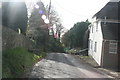
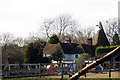
Greensand Way approaching Liverton Street
Image: © N Chadwick
Taken: 25 Nov 2012
0.00 miles
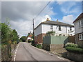
2
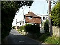
8 Churchill Cottages, Liverton Street
The owner of number 8 wanted to blend the extension into the rest of the cottage. He applied for planning permission to do so, through Maidstone Borough Council (refs 11/0500 and 11/0499), but this was not granted. Churchill Cottages is the oldest building in the hamlet of Liverton Street.
Image: © John Baker
Taken: 25 May 2011
0.03 miles
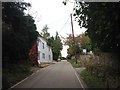
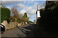
9
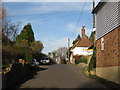
Headcorn Road, Liverton Street, Kent
Image: © Oast House Archive
Taken: 19 Nov 2008
0.04 miles