IMAGES TAKEN NEAR TO
Lenham Heath, MAIDSTONE, ME17 2JJ
Introduction
This page details the photographs taken nearby to ME17 2JJ by members of the Geograph project.
The Geograph project started in 2005 with the aim of publishing, organising and preserving representative images for every square kilometre of Great Britain, Ireland and the Isle of Man.

There are currently over 7.5m images from over14,400 individuals and you can help contribute to the project by visiting https://www.geograph.org.uk
Image Map
Images are licensed for reuse under creativecommons.org/licenses/by-sa/2.0
Notes
- Clicking on the map will re-center to the selected point.
- The higher the marker number, the further away the image location is from the centre of the postcode.
Image Listing (18 Images Found)
Images are licensed for reuse under creativecommons.org/licenses/by-sa/2.0
Image
Details
Distance
1
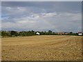
Rainbow from Bull Hill
The left edge of the field is bordered by Lenham Forstal Road, the hedge (and houses) at the foot of the rainbow are on Crabtree Lane.
Image: © Penny Mayes
Taken: 29 Aug 2006
0.05 miles
2
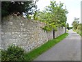
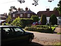
Crabbe Farm
On Crabtree Lane, Lenham Heath. The stone wall effectively conceals the building from view but I gather from the listing details that it is a 17th century farmhouse with the ground floor in stone and the upper storey in brick.
Image: © Penny Mayes
Taken: 29 Aug 2006
0.10 miles
3
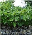
Fig tree at Crabbe Farm
Peeping over the stone wall of Image, Crab Tree Lane, Lenham Heath.
Image: © Penny Mayes
Taken: 29 Aug 2006
0.10 miles
4
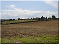
Bull Hill
Viewed from the junction of Lenham Forstal Road and Crabtree Lane.
Image: © Penny Mayes
Taken: 29 Aug 2006
0.16 miles
5
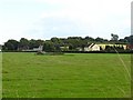
Dead barn at Lenham Heath
Viewed from Crabtree Lane, only the roof remains of this building in the middle of a meadow. The building is marked on the 1:50,000 OS map.
Image: © Penny Mayes
Taken: 29 Aug 2006
0.18 miles
6
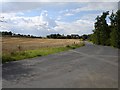
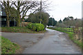
Towards Lenham Forstal
From the top of Crabtree Lane. Forstal seems to be a common placename modifier in this area for a small community near a larger one.
Image: © Penny Mayes
Taken: 29 Aug 2006
0.19 miles
7
Lenham Forstal
A small group of houses at the junction of Bull Hill and Lenham Forstal Road. Forstal is a common place name modifier in this area, usually used for a small community near another.
Image: © Penny Mayes
Taken: 29 Aug 2006
0.19 miles
8
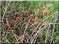
Cuckoo Pint berries
On the triangle of grass at Lenham Forstal.
Image: © Penny Mayes
Taken: 29 Aug 2006
0.19 miles
10
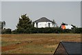
The Windmill, Mount Pleasant
Former four sail windmill.
Image: © Oast House Archive
Taken: 2 Jun 2020
0.20 miles