IMAGES TAKEN NEAR TO
Country Ways, MAIDSTONE, ME17 2JF
Introduction
This page details the photographs taken nearby to Country Ways, ME17 2JF by members of the Geograph project.
The Geograph project started in 2005 with the aim of publishing, organising and preserving representative images for every square kilometre of Great Britain, Ireland and the Isle of Man.

There are currently over 7.5m images from over14,400 individuals and you can help contribute to the project by visiting https://www.geograph.org.uk
Image Map
Images are licensed for reuse under creativecommons.org/licenses/by-sa/2.0
Notes
- Clicking on the map will re-center to the selected point.
- The higher the marker number, the further away the image location is from the centre of the postcode.
Image Listing (15 Images Found)
Images are licensed for reuse under creativecommons.org/licenses/by-sa/2.0
Image
Details
Distance
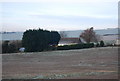
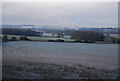
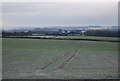
1
View from byway
This is a view of Lenham Heath from a byway from Waterditch Lane.
The North Downs Way (long distance path) follows hedgeline in foreground.
Image: © David Anstiss
Taken: 10 May 2009
0.02 miles
4
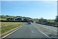
A20 heading east
Approaching a residential close called Country Ways.
Image: © Robin Webster
Taken: 8 Feb 2018
0.05 miles
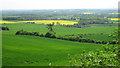
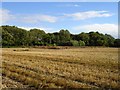
5
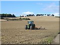
Rolling on Cobham Farm
This field runs down from the Pilgrims Way' / North Downs Way (shown by the hedgeline running left to right) to the A20, Maidstone to Ashford road. The track just visible on the right goes to Cobham Farm.
Image: © Penny Mayes
Taken: 29 Aug 2006
0.06 miles
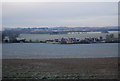
7
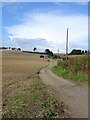
Cobham Farm
From the bottom of the track where it meets the A20 Maidstone to Ashford road.
Image: © Penny Mayes
Taken: 29 Aug 2006
0.14 miles
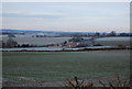
8
Field by the Pilgrims' Way
Acton farm can be seen in the background.
Image: © N Chadwick
Taken: 28 Nov 2010
0.17 miles
9
Woodland and rape stubble
Looking south east from the footpath pictured here http://www.geograph.org.uk/photo/229371
Image: © Penny Mayes
Taken: 29 Aug 2006
0.20 miles