IMAGES TAKEN NEAR TO
Headcorn Road, MAIDSTONE, ME17 2HS
Introduction
This page details the photographs taken nearby to Headcorn Road, ME17 2HS by members of the Geograph project.
The Geograph project started in 2005 with the aim of publishing, organising and preserving representative images for every square kilometre of Great Britain, Ireland and the Isle of Man.

There are currently over 7.5m images from over14,400 individuals and you can help contribute to the project by visiting https://www.geograph.org.uk
Image Map
Images are licensed for reuse under creativecommons.org/licenses/by-sa/2.0
Notes
- Clicking on the map will re-center to the selected point.
- The higher the marker number, the further away the image location is from the centre of the postcode.
Image Listing (21 Images Found)
Images are licensed for reuse under creativecommons.org/licenses/by-sa/2.0
Image
Details
Distance
1
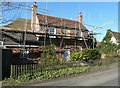
Renovation of Leadingcross Green Farmhouse, Headcorn Road
It is a grade II listed building that is now a house but was formerly a farmhouse. It probably of 15th century origin but was re-fronted in the early 19th century. There are north and west additions that date from the 20th century
http://www.britishlistedbuildings.co.uk/en-173896-leadingcross-green-farmhouse-lenham-kent
Image: © John Baker
Taken: 9 Mar 2014
0.01 miles
2
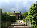
Allsorts in this garden
As seen from footpath from Old Ham Lane to Headocrn Road. This house is called the Lodge, is part of Leading Cross Green farm. Lake in garden had flooded over footpath.
Image: © David Anstiss
Taken: 22 Feb 2009
0.03 miles
3
House in Boughton Road
This is on the southern outskirts of Lenham, just after the split from Headcorn Road.
Image: © Marathon
Taken: 7 May 2022
0.05 miles
4
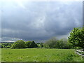
Stormy weather approaching
This view is from Boughton Road. Although the weather became ever more threatening, it passed to the south.
Image: © Marathon
Taken: 7 May 2022
0.13 miles
5
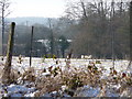
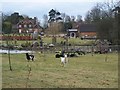
Sheep in field near Lenham
Looking across from the excursion train towards the sheep in the snow covered field.
Image: © Christine Matthews
Taken: 22 Dec 2009
0.17 miles
6
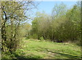
Entrance to Kiln Wood, near Lenham
The entrance is in Headcorn Road, south of the village of Lenham. Kiln Wood is a 6-hectare (15-acre) nature reserve managed by Kent Wildlife Trust. The wood is mainly oak, hornbeam and hazel.
Image: © pam fray
Taken: 21 Apr 2019
0.20 miles
7
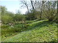
Pond in Kiln Wood, near Lenham
Situated at the northern end of the reserve. The entrance is in Headcorn Road, south of the village of Lenham. Kiln Wood is a 6-hectare (15-acre) nature reserve managed by Kent Wildlife Trust. The wood is mainly oak, hornbeam and hazel.
Image: © pam fray
Taken: 21 Apr 2019
0.22 miles
9
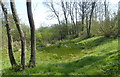
Kiln Wood, near Lenham
Situated at the northern end of the reserve. The entrance is in Headcorn Road, south of the village of Lenham. Kiln Wood is a 6-hectare (15-acre) nature reserve managed by Kent Wildlife Trust. The wood is mainly oak, hornbeam and hazel.
Image: © pam fray
Taken: 21 Apr 2019
0.23 miles