IMAGES TAKEN NEAR TO
Essinger Walk, ME17 2GL
Introduction
This page details the photographs taken nearby to Essinger Walk, ME17 2GL by members of the Geograph project.
The Geograph project started in 2005 with the aim of publishing, organising and preserving representative images for every square kilometre of Great Britain, Ireland and the Isle of Man.

There are currently over 7.5m images from over14,400 individuals and you can help contribute to the project by visiting https://www.geograph.org.uk
Image Map
Images are licensed for reuse under creativecommons.org/licenses/by-sa/2.0
Notes
- Clicking on the map will re-center to the selected point.
- The higher the marker number, the further away the image location is from the centre of the postcode.
Image Listing (74 Images Found)
Images are licensed for reuse under creativecommons.org/licenses/by-sa/2.0
Image
Details
Distance
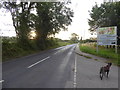
2

Old Milestone by Old Ashford Road, Lenham
Stone post (plates lost) by the UC road (was A20), in parish of LENHAM (ASHFORD District), Old Ashford Road, East of footpath to North Downs Way, just East of, and opposite telegraph pole in verge scrub, on North side of road. Maidstone double iron plate, erected by the Ashford & Maidstone turnpike trust in the 19th century.
Inscription once read:-
: (ASHFORD / 9 / FOLKESTONE / 25) : : (MAIDSTONE / 9 / LONDON / 44) :
Carved benchmark and rivet on top.
Kent HER.
HER Number: TQ 95 SW 20 https://www.heritagegateway.org.uk/Gateway/Results_Single.aspx?uid=MKE97752&resourceID=1005
Milestone Society National ID: KE_LF44.
Image: © C Woodward
Taken: 27 Feb 2012
0.05 miles
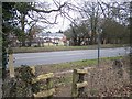
3

Field, Old Ashford Road
The field will, in the near future, disappear under a large housing estate.
Planning permission has been granted Maidstone Borough Council under application number 17/500357/HYBRID for a “hybrid planning application comprising: - Full Application - Erection of 49 dwellings and associated infrastructure, landscaping and open space [&] Outline Application - Erection of 102 dwellings (access, layout and landscaping to be sought). The location was described as “land north of Old Ashford Road”.
Image: © John Baker
Taken: 19 Nov 2017
0.06 miles
4
Footpath crosses A20 Ashford Road
Leads from North Downs Way (long distance path) over busy road (many lorries) into Lenham village.
Image: © David Anstiss
Taken: 22 Feb 2009
0.09 miles
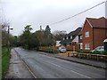
6

Lenham Community Centre
Built and opened at the turn of the century. The white lantern feature at the top of the roof is shaped to imitate the weathervane vents on Kentish oast houses. In this case it doesn't move. Photo taken from the public right of way which passes through the car park.
Image: © Mike Sharpe
Taken: 24 Sep 2009
0.10 miles
8
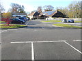
Lenham Community Centre
Accessed from Old Ashford Road via Groom Way.
Image: © John Baker
Taken: 19 Nov 2017
0.12 miles
9
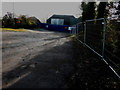
Track to Tanyard Farm, Old Ashford Road
Just visible, beyond the hoarding, are the roof timbers of one of the houses, which is in the process of being built.
Planning permission was granted by Maidstone Borough Council under application number 14/503309/FULL for the “conversion of 3 agricultural barns for residential use and erection of 3 new dwellings with associated car barns and landscaping”.
Image: © John Baker
Taken: 19 Nov 2017
0.12 miles
10
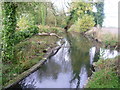
Sluice at Tanyard Farm
Seen from the footpath between Lenham Churchyard and Tanyard Farm, this seems to have been the sluice to power a mill which used to exist just behind where I am standing.
Image: © Marathon
Taken: 2 Nov 2013
0.12 miles