IMAGES TAKEN NEAR TO
Ashford Road, MAIDSTONE, ME17 2DU
Introduction
This page details the photographs taken nearby to Ashford Road, ME17 2DU by members of the Geograph project.
The Geograph project started in 2005 with the aim of publishing, organising and preserving representative images for every square kilometre of Great Britain, Ireland and the Isle of Man.

There are currently over 7.5m images from over14,400 individuals and you can help contribute to the project by visiting https://www.geograph.org.uk
Image Map (Loading...)


Getting Data...Please wait
Leaflet Map data © OpenStreetMap
Images are licensed for reuse under creativecommons.org/licenses/by-sa/2.0
Notes
- Clicking on the map will re-center to the selected point.
- The higher the marker number, the further away the image location is from the centre of the postcode.
Image Listing (31 Images Found)
Images are licensed for reuse under creativecommons.org/licenses/by-sa/2.0
Image
Details
Distance
2
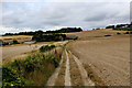
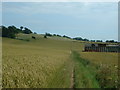
North Downs Way approaching Cobham Farm
Following the National Trail from the south, as it approaches Cobham Farm
Image: © Chris Heaton
Taken: 10 Aug 2015
0.00 miles
4
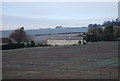
Cobham Farm and the Pilgrim's Way
This ancient trackway follows the Pilgrim's Way, also the North Downs Way National Trail, National Cycle Network route 17 and Pilgrim's Cycle Trail.
Image: © Oliver Dixon
Taken: 13 May 2016
0.01 miles
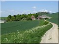
5
The Pilgrim's Way near Cobham Farm
The ancient Pilgrim's Way to Canterbury, here passing through ripe fields of corn. Over this section, the Pilgrim's Way runs jointly with the modern National Trail, the North Downs Way
Image: © Oliver Dixon
Taken: 16 Jul 2002
0.02 miles
7
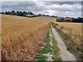
The Pilgrim's Way near Cobham Farm
Taken from the same spot as Oliver Dixon's image Image almost exactly seven years later, this gives an interesting comparison on how little has changed in the period.
Image: © Andy Stephenson
Taken: 15 Jul 2009
0.04 miles
9
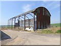
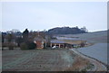
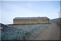
Barn at Cobham Farm
Beside the Pilgrim's Way.
Image: © Oliver Dixon
Taken: 13 May 2016
0.05 miles
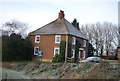
10
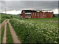
Pilgrim's Way at Cobham Farm
The Pilgrim's Way was an ancient trackway used as a trading route by prehistoric people. It has been dated by archaeological finds to 500–450 BC, but probably has been in existence since the Stone Age. It is also supposed to be the historic route taken by pilgrims from Winchester to the shrine of Thomas Becket at Canterbury. It certainly was one of them but not the only one. Parts of it, as here, are followed by the North Downs Way.
Cobham Farm is approached here. The barn seems to be becoming increasingly derelict.
Image: © Marathon
Taken: 7 May 2022
0.05 miles