IMAGES TAKEN NEAR TO
Lenham, MAIDSTONE, ME17 2DN
Introduction
This page details the photographs taken nearby to ME17 2DN by members of the Geograph project.
The Geograph project started in 2005 with the aim of publishing, organising and preserving representative images for every square kilometre of Great Britain, Ireland and the Isle of Man.

There are currently over 7.5m images from over14,400 individuals and you can help contribute to the project by visiting https://www.geograph.org.uk
Image Map
Images are licensed for reuse under creativecommons.org/licenses/by-sa/2.0
Notes
- Clicking on the map will re-center to the selected point.
- The higher the marker number, the further away the image location is from the centre of the postcode.
Image Listing (22 Images Found)
Images are licensed for reuse under creativecommons.org/licenses/by-sa/2.0
Image
Details
Distance
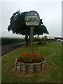
3

Lenham Village Sign
Some villages have just the one sign but Lenham has at least three. This is the one at the eastern approach off the A20 along Old Ashford Road. The North Downs provide a backdrop. For a close up see http://www.geograph.org.uk/photo/3102567
Image: © Marathon
Taken: 26 Aug 2012
0.04 miles
4
Close up of the Lenham Village Sign
Some villages have just the one sign but Lenham has at least three. This is the one at the eastern approach off the A20 along Old Ashford Road - for its context see http://www.geograph.org.uk/photo/3100352
Image: © Marathon
Taken: 26 Aug 2012
0.04 miles
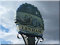
6
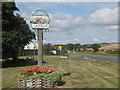
Lenham Village Sign
This is one of a pair of signs. This one is on a green at the junction of the A20 Ashford Road and Old Ashford Road (unseen, heading left into the village).
The North Downs is on the right. Compare with Image It depicts the Church (St Mary's), the hillside cross (seen in Image).
Image: © David Anstiss
Taken: 22 Aug 2009
0.07 miles
8
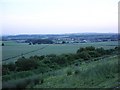
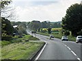
View from the chalk quarry
Note the well-defined footpath through the wheat field which is heading straight for the SW corner of the square. The hedgerow in the foreground shows the position of the road, which is also the Pilgrims' Way for about 300 metres just here, before the road turns SSW (out of shot to the right) and meets the footpath at the junction with the A20.
Image: © Penny Mayes
Taken: 15 Jun 2006
0.08 miles
9
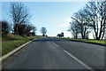
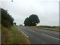
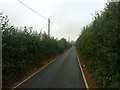
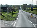
Ashford Road, A20
Heading towards Ashford.
Image: © Robin Webster
Taken: 30 Jan 2018
0.08 miles