IMAGES TAKEN NEAR TO
Church Road, MAIDSTONE, ME17 2BA
Introduction
This page details the photographs taken nearby to Church Road, ME17 2BA by members of the Geograph project.
The Geograph project started in 2005 with the aim of publishing, organising and preserving representative images for every square kilometre of Great Britain, Ireland and the Isle of Man.

There are currently over 7.5m images from over14,400 individuals and you can help contribute to the project by visiting https://www.geograph.org.uk
Image Map
Images are licensed for reuse under creativecommons.org/licenses/by-sa/2.0
Notes
- Clicking on the map will re-center to the selected point.
- The higher the marker number, the further away the image location is from the centre of the postcode.
Image Listing (51 Images Found)
Images are licensed for reuse under creativecommons.org/licenses/by-sa/2.0
Image
Details
Distance
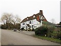
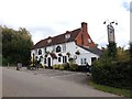
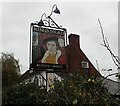
4
King's Head, Grafty Green
Freehouse on Headcorn Road.
Also see Image
Image: © Oast House Archive
Taken: 6 Apr 2011
0.07 miles
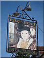
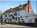
6
The sign for the King's Head at Grafty Green
The king in question is Edward VIth, son of Henry VIIIth and half brother of Elizabeth I.
Image: © Marathon
Taken: 1 Nov 2020
0.07 miles