IMAGES TAKEN NEAR TO
Old Mill Road, MAIDSTONE, ME17 1XD
Introduction
This page details the photographs taken nearby to Old Mill Road, ME17 1XD by members of the Geograph project.
The Geograph project started in 2005 with the aim of publishing, organising and preserving representative images for every square kilometre of Great Britain, Ireland and the Isle of Man.

There are currently over 7.5m images from over14,400 individuals and you can help contribute to the project by visiting https://www.geograph.org.uk
Image Map
Images are licensed for reuse under creativecommons.org/licenses/by-sa/2.0
Notes
- Clicking on the map will re-center to the selected point.
- The higher the marker number, the further away the image location is from the centre of the postcode.
Image Listing (16 Images Found)
Images are licensed for reuse under creativecommons.org/licenses/by-sa/2.0
Image
Details
Distance
1
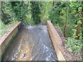
Old mill race for Brandescombe Mill
A lake was created above what is now Old Mill Lane on the River Len, a river ten miles long which rises on the Greensand Ridge at Lenham and flows into the river Medway at Maidstone - see http://en.wikipedia.org/wiki/River_Len The lake was created by damming the river for Brandescombe Mill. To quote Wikipedia for the history of the mill: "This mill was presented to the Priory of Leeds by Robert de Crevecoeur the Younger. The mill was also mentioned in the will of Daniel de Crevequer, who died in 1177. At that time it was a corn mill. Leeds priory was dissolved in 1539 and the mill was still in the ownership of the priory then. In 1628, Thomas Fludd and Ralphe Buffkin sold the mill to William Cage of Lincoln's Inn, Middlesex. By this time it was a fulling mill. Cage was still the owner in 1689, when the mill was in the occupation of William Tompkin and had previously been in the occupation of Bob Potter. Potter remained in occupation until at least 1707. Hasted noted the mill was still working in 1798 and Greenwood's map of 1822 marks the mill as Shilling Mill. The mill probably had a breast-shot waterwheel as the head was not sufficient for an overshot wheel. Fulling Mill had ceased to be used as a mill by 1843, there being no entry in Bagshaw's Directory of that year. The surviving building is of fifteenth century date."
This is the view from Old Mill Lane looking down the old mill race. For a photograph of the lake see http://www.geograph.org.uk/photo/3744531
Image: © Marathon
Taken: 12 Nov 2013
0.02 miles
2
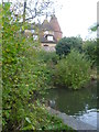
Old Mill Oast, Old Mill Road, Leeds, Kent
Triple round kiln oast house.
Image: © Oast House Archive
Taken: 19 Aug 2009
0.05 miles
3
Old Mill Road crossing the River Len
A lake was created on the River Len, a river ten miles long which rises on the Greensand Ridge at Lenham and flows into the river Medway at Maidstone - see http://en.wikipedia.org/wiki/River_Len The lake was created by damming the river for Brandescombe Mill. To quote Wikipedia for the history of the mill: "This mill was presented to the Priory of Leeds by Robert de Crevecoeur the Younger. The mill was also mentioned in the will of Daniel de Crevequer, who died in 1177. At that time it was a corn mill. Leeds priory was dissolved in 1539 and the mill was still in the ownership of the priory then. In 1628, Thomas Fludd and Ralphe Buffkin sold the mill to William Cage of Lincoln's Inn, Middlesex. By this time it was a fulling mill. Cage was still the owner in 1689, when the mill was in the occupation of William Tompkin and had previously been in the occupation of Bob Potter. Potter remained in occupation until at least 1707. Hasted noted the mill was still working in 1798 and Greenwood's map of 1822 marks the mill as Shilling Mill. The mill probably had a breast-shot waterwheel as the head was not sufficient for an overshot wheel. Fulling Mill had ceased to be used as a mill by 1843, there being no entry in Bagshaw's Directory of that year. The surviving building is of fifteenth century date."
This photograph looks along Old Mill Lane where it crosses the Len. The lake is to the right - see http://www.geograph.org.uk/photo/3744531 and the old mill race is to the left - see http://www.geograph.org.uk/photo/3744535
Image: © Marathon
Taken: 12 Nov 2013
0.05 miles
4
Old Mill Oast, Old Mill Road, Leeds, Kent
Triple round kiln oast house.
Image: © Oast House Archive
Taken: 28 Jul 2009
0.06 miles
5
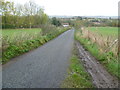
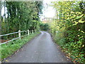
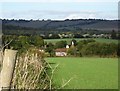
Old Mill Road
Old Mill Road leads from the outskirts of Leeds to the old mill on the River Len in the valley ahead. There is a dammed lake just this side of the oast houses which can be seen to the right. These are at Old Mill Farm. The North Downs are on the horizon.
Image: © Marathon
Taken: 12 Nov 2013
0.07 miles
7
Old Mill Oast, Old Mill Road, Leeds, Kent
Image: © Oast House Archive
Taken: 26 Nov 2010
0.08 miles
8
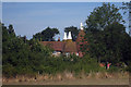
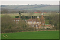
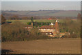
Oasts at Old Mill Farm
The oasts are seen from Old Mill Road where it crosses the lake created by the River Len for the former Brandescombe Mill. For more about the lake and the mill see http://www.geograph.org.uk/photo/3744531
Image: © Marathon
Taken: 12 Nov 2013
0.08 miles
9
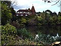
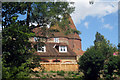
Old Mill House
I don't think this building was the actual mill since it is so high above the millpond which empties into a ravine just west of here.
Image: © Penny Mayes
Taken: 20 Oct 2005
0.09 miles
10
Old Mill House
A wider view from the south. Coldblow on the north downs is on the horizon above the house.
Image: © Penny Mayes
Taken: 20 Oct 2005
0.09 miles