IMAGES TAKEN NEAR TO
Kings Square, MAIDSTONE, ME17 1WL
Introduction
This page details the photographs taken nearby to Kings Square, ME17 1WL by members of the Geograph project.
The Geograph project started in 2005 with the aim of publishing, organising and preserving representative images for every square kilometre of Great Britain, Ireland and the Isle of Man.

There are currently over 7.5m images from over14,400 individuals and you can help contribute to the project by visiting https://www.geograph.org.uk
Image Map
Images are licensed for reuse under creativecommons.org/licenses/by-sa/2.0
Notes
- Clicking on the map will re-center to the selected point.
- The higher the marker number, the further away the image location is from the centre of the postcode.
Image Listing (50 Images Found)
Images are licensed for reuse under creativecommons.org/licenses/by-sa/2.0
Image
Details
Distance
2
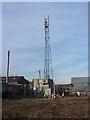
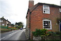
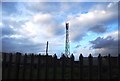
O2 Mobile Phone Mast in farm buildings
In Ledian Farm. As seen from Burgess Hall Drive footpath.
Image: © David Anstiss
Taken: 26 Feb 2009
0.02 miles
5

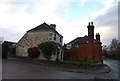
Oast House at Ledian Farm, Upper Street, Leeds
Image: © Oast House Archive
Taken: 26 Nov 2015
0.04 miles
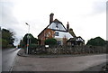
6

Oast House at Ledian Farm, Upper Street, Leeds
Image: © Oast House Archive
Taken: 26 Nov 2015
0.04 miles