IMAGES TAKEN NEAR TO
Back Street, MAIDSTONE, ME17 1TE
Introduction
This page details the photographs taken nearby to Back Street, ME17 1TE by members of the Geograph project.
The Geograph project started in 2005 with the aim of publishing, organising and preserving representative images for every square kilometre of Great Britain, Ireland and the Isle of Man.

There are currently over 7.5m images from over14,400 individuals and you can help contribute to the project by visiting https://www.geograph.org.uk
Image Map
Images are licensed for reuse under creativecommons.org/licenses/by-sa/2.0
Notes
- Clicking on the map will re-center to the selected point.
- The higher the marker number, the further away the image location is from the centre of the postcode.
Image Listing (4 Images Found)
Images are licensed for reuse under creativecommons.org/licenses/by-sa/2.0
Image
Details
Distance
1
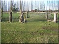
Footpath junction in Arnold Farm field
Footpath from Horseshoes Lane stops at this fence line and coppiced trees. A path the heads left to Back Street. Also a path heads right to Sutton Road,through Rumswood Green Farm.
Image: © David Anstiss
Taken: 26 Feb 2009
0.12 miles
2
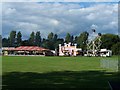
Fairground At Langley Green
On the village green.
Image: © Geoff Pick
Taken: 28 Aug 2010
0.23 miles
3
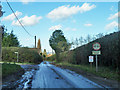
Back Street
A footpath to Avery Lane leaves at the left.
Image: © Robin Webster
Taken: 16 Feb 2014
0.24 miles