IMAGES TAKEN NEAR TO
Lower Street, MAIDSTONE, ME17 1RR
Introduction
This page details the photographs taken nearby to Lower Street, ME17 1RR by members of the Geograph project.
The Geograph project started in 2005 with the aim of publishing, organising and preserving representative images for every square kilometre of Great Britain, Ireland and the Isle of Man.

There are currently over 7.5m images from over14,400 individuals and you can help contribute to the project by visiting https://www.geograph.org.uk
Image Map
Images are licensed for reuse under creativecommons.org/licenses/by-sa/2.0
Notes
- Clicking on the map will re-center to the selected point.
- The higher the marker number, the further away the image location is from the centre of the postcode.
Image Listing (121 Images Found)
Images are licensed for reuse under creativecommons.org/licenses/by-sa/2.0
Image
Details
Distance
1
Foley Oast, Lower Street, Leeds, Kent
Image: © Oast House Archive
Taken: 29 Jun 2009
0.01 miles
3
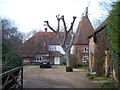
Foley Oast, Leeds
On access road for Foley Farm, from Lower Street, Leeds.
Image: © David Anstiss
Taken: 26 Feb 2009
0.02 miles
4
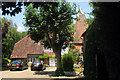
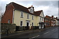
Foley Oast, Foley Farm Cottage and Woodbine Cottage
Foley Oast (in the background) is an early 19th century former oast, converted to a house in the late 20th century. Foley Farm Cottage (on the left) originates from the 15th century with a 19th century frontage and Woodbine Cottage (on the right) dates from the 16th century, with a 19th century frontage and addition
All are grade II listed - see www.historicengland.org.uk/listing/the-list/list-entry/1336307, www.historicengland.org.uk/listing/the-list/list-entry/1185785 and www.historicengland.org.uk/listing/the-list/list-entry/1185775.
Image: © Ian Capper
Taken: 20 Jun 2012
0.02 miles
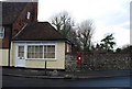
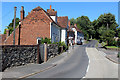
7
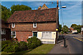
Empire Cottage
Part of a 17th century grade II listed house - see www.historicengland.org.uk/listing/the-list/list-entry/1086134.
Image: © Ian Capper
Taken: 20 Jun 2012
0.04 miles
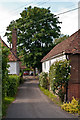
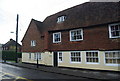
8
Brook House
Early 18th and early 19th century house. Grade II listed - see www.historicengland.org.uk/listing/the-list/list-entry/1299560.
Image: © Ian Capper
Taken: 20 Jun 2012
0.04 miles
9
Lower Street, Leeds in 1969
The building nearest to the camera is Mayfield House, the next (with the car parked outside) is Oast View, while, at the far end of the row are numbers 1 & 2 Stanley Cottages
Image: © John Baker
Taken: Unknown
0.04 miles
10
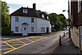
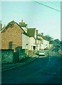
In the Village of Leeds
The B2163 heading north through the village of Leeds
Image: © Chris Heaton
Taken: 12 Aug 2016
0.04 miles