IMAGES TAKEN NEAR TO
Penfold Hill, MAIDSTONE, ME17 1RG
Introduction
This page details the photographs taken nearby to Penfold Hill, ME17 1RG by members of the Geograph project.
The Geograph project started in 2005 with the aim of publishing, organising and preserving representative images for every square kilometre of Great Britain, Ireland and the Isle of Man.

There are currently over 7.5m images from over14,400 individuals and you can help contribute to the project by visiting https://www.geograph.org.uk
Image Map
Images are licensed for reuse under creativecommons.org/licenses/by-sa/2.0
Notes
- Clicking on the map will re-center to the selected point.
- The higher the marker number, the further away the image location is from the centre of the postcode.
Image Listing (13 Images Found)
Images are licensed for reuse under creativecommons.org/licenses/by-sa/2.0
Image
Details
Distance
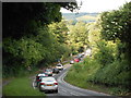
1
Bridge Across River Len (1)
This bridge takes the B2163 across the River Len. It is too narrow to permit simultaneous two way travel. Priority is given to vehicles travelling in the opposite direction to the view here. However, at busy times there are tailbacks towards the roundabout behind and so traffic in the opposite direction sometimes relinquishes priority when it is obviously not going to be of any use to them. For the opposite view, see here Image]
Image: © Danny P Robinson
Taken: 25 Jun 2013
0.05 miles
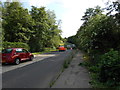
2
Penfold Hill, Leeds, Kent
Looking towards the "pinch point", the bridge over the River Len. For the opposite view, see here Image]
Image: © Danny P Robinson
Taken: 25 Jun 2013
0.05 miles
3
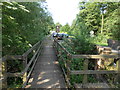
Bridge Across River Len (2)
Showing the pedestrian walkway.
Image: © Danny P Robinson
Taken: 25 Jun 2013
0.05 miles
4
Bridge Across River Len (3)
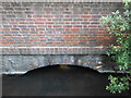
A close-up, showing the clear water and the level that day.
Image: © Danny P Robinson
Taken: 25 Jun 2013
0.05 miles
5
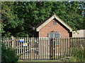
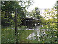
Plant Room near River Len
This is operated by Southern Water, but I don't know what the building is actually for. The sign on the gate merely gives an emergency phone number, but no description of the building itself.
Image: © Danny P Robinson
Taken: 25 Jun 2013
0.06 miles
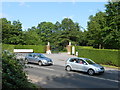
6
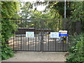
Leeds Gas Pressure Reducing Station (1)
Operated by Southern Gas Networks.
Image: © Danny P Robinson
Taken: 25 Jun 2013
0.07 miles
7
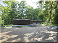
Leeds Gas Pressure Reducing Station (2)
Operated by Southern Gas Networks
Image: © Danny P Robinson
Taken: 25 Jun 2013
0.07 miles
8
Leeds Gas Pressure Reducing Station (3)
Operated by Southern Gas Networks.
Image: © Danny P Robinson
Taken: 25 Jun 2013
0.08 miles
9
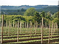
Fruit Farm near Leeds, Kent
This is the same view as Image] but with a zoom lens to show the North Downs in the background.
Image: © Danny P Robinson
Taken: 25 Jun 2013
0.10 miles