IMAGES TAKEN NEAR TO
Ashford Road, MAIDSTONE, ME17 1RE
Introduction
This page details the photographs taken nearby to Ashford Road, ME17 1RE by members of the Geograph project.
The Geograph project started in 2005 with the aim of publishing, organising and preserving representative images for every square kilometre of Great Britain, Ireland and the Isle of Man.

There are currently over 7.5m images from over14,400 individuals and you can help contribute to the project by visiting https://www.geograph.org.uk
Image Map (Loading...)


Getting Data...Please wait
Leaflet Map data © OpenStreetMap
Images are licensed for reuse under creativecommons.org/licenses/by-sa/2.0
Notes
- Clicking on the map will re-center to the selected point.
- The higher the marker number, the further away the image location is from the centre of the postcode.
Image Listing (25 Images Found)
Images are licensed for reuse under creativecommons.org/licenses/by-sa/2.0
Image
Details
Distance
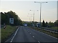
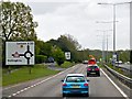
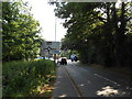
4

Roundabout on the A20, Eyhorne Street
The Sebastian Coe Health Club is on the left
Image: © David Howard
Taken: 21 Apr 2013
0.13 miles

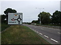
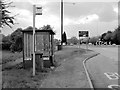
7
Approach to A20 Roundabout, Eyhorne Street
Image: © Danny P Robinson
Taken: 25 Jun 2013
0.14 miles
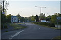
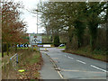
10
Path to Eyhorne Street
From Ashford Road
Image: © David Dixon
Taken: 13 May 2013
0.18 miles