IMAGES TAKEN NEAR TO
Hook Lane, MAIDSTONE, ME17 1QZ
Introduction
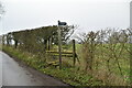
This page details the photographs taken nearby to Hook Lane, ME17 1QZ by members of the Geograph project.
The Geograph project started in 2005 with the aim of publishing, organising and preserving representative images for every square kilometre of Great Britain, Ireland and the Isle of Man.

There are currently over 7.5m images from over14,400 individuals and you can help contribute to the project by visiting https://www.geograph.org.uk
Image Map
Images are licensed for reuse under creativecommons.org/licenses/by-sa/2.0
Notes
- Clicking on the map will re-center to the selected point.
- The higher the marker number, the further away the image location is from the centre of the postcode.
Image Listing (10 Images Found)
Images are licensed for reuse under creativecommons.org/licenses/by-sa/2.0
Image
Details
Distance
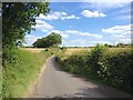
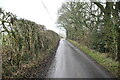
2
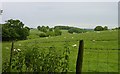
Meadow near Hucking
One of the joys of landscape "behind" the North Downs are all the little rolling valleys.
Image: © Penny Mayes
Taken: 11 Jun 2005
0.07 miles
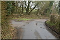
8
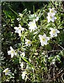
Wood anemones near Hucking
Beside Rumstead Lane.
Image: © Penny Mayes
Taken: 8 Apr 2006
0.21 miles