IMAGES TAKEN NEAR TO
Bredgar Road, MAIDSTONE, ME17 1QN
Introduction
This page details the photographs taken nearby to Bredgar Road, ME17 1QN by members of the Geograph project.
The Geograph project started in 2005 with the aim of publishing, organising and preserving representative images for every square kilometre of Great Britain, Ireland and the Isle of Man.

There are currently over 7.5m images from over14,400 individuals and you can help contribute to the project by visiting https://www.geograph.org.uk
Image Map
Images are licensed for reuse under creativecommons.org/licenses/by-sa/2.0
Notes
- Clicking on the map will re-center to the selected point.
- The higher the marker number, the further away the image location is from the centre of the postcode.
Image Listing (4 Images Found)
Images are licensed for reuse under creativecommons.org/licenses/by-sa/2.0
Image
Details
Distance
1
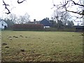
Cooper's Farm
As seen from footpath from Hollingbourne Hill to Colyers Wents.
Image: © David Anstiss
Taken: 29 Jan 2009
0.01 miles
2
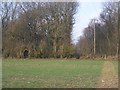
Footpaths to Stockbury Wood
Path from Cooper's Farm meets path from Hollingbourne Hill (arch) both leading to Church Road, near Colyers Wents.
Image: © David Anstiss
Taken: 29 Jan 2009
0.19 miles
3
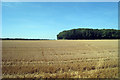
Crop Field off Hollingbourne Hill
Looking towards Park Wood.
Image: © Oast House Archive
Taken: 19 Aug 2009
0.20 miles
4
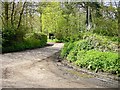
Colyers Wents
In local parlance a "Five went way" (junction of 5 roads) although two of the "ways" are little more than tracks.
Image: © Penny Mayes
Taken: 29 Apr 2005
0.23 miles