IMAGES TAKEN NEAR TO
Hollingbourne, MAIDSTONE, ME17 1QL
Introduction
This page details the photographs taken nearby to ME17 1QL by members of the Geograph project.
The Geograph project started in 2005 with the aim of publishing, organising and preserving representative images for every square kilometre of Great Britain, Ireland and the Isle of Man.

There are currently over 7.5m images from over14,400 individuals and you can help contribute to the project by visiting https://www.geograph.org.uk
Image Map
Images are licensed for reuse under creativecommons.org/licenses/by-sa/2.0
Notes
- Clicking on the map will re-center to the selected point.
- The higher the marker number, the further away the image location is from the centre of the postcode.
Image Listing (16 Images Found)
Images are licensed for reuse under creativecommons.org/licenses/by-sa/2.0
Image
Details
Distance
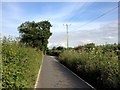
1
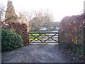
Tile Barn Cottage
On Ringlestone Road. Farm cottage now divided into 2 semi-detached cottages. Viewed is number 1.
Image: © David Anstiss
Taken: 29 Jan 2009
0.04 miles
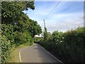
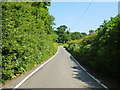
3
Ringlestone Road
Looking East, Morning Dawn to left.
Image: © Oast House Archive
Taken: 1 Mar 2010
0.07 miles
4
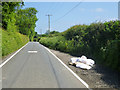
Fly tipping on Ringlestone Road
They look like insulation blankets.
Image: © Robin Webster
Taken: 9 Jun 2016
0.12 miles
7
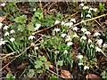
Snowdrops (Galanthus nivalis)
Beside Ringlestone Road.
Image: © Penny Mayes
Taken: 31 Jan 2007
0.18 miles
8
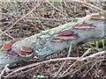
Bracket fungus
On a fallen tree beside Ringlestone Road.
Image: © Penny Mayes
Taken: 31 Jan 2007
0.18 miles
9
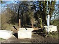
When is a byway not a byway?
When it's been 'Closed for resurfacing'. This is Drake Lane north of Ringlestone Road, part of an old trackway (designated KH645) which runs from near Leeds Castle Image to Bedmonton Image Resurfacing work should be finished by March 2007.
Image: © Penny Mayes
Taken: 31 Jan 2007
0.18 miles
10
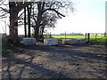
Drake Lane - closed for refurbishment
A designated Byway (KH645), Drake Lane is closed for six months for some much needed resurfacing (see http://www.geograph.org.uk/photo/230510 and http://www.geograph.org.uk/photo/230217 ) although I'm not sure these blocks would stop the Unimog...
Image: © Penny Mayes
Taken: 31 Jan 2007
0.20 miles