IMAGES TAKEN NEAR TO
Ashford Road, MAIDSTONE, ME17 1PG
Introduction
This page details the photographs taken nearby to Ashford Road, ME17 1PG by members of the Geograph project.
The Geograph project started in 2005 with the aim of publishing, organising and preserving representative images for every square kilometre of Great Britain, Ireland and the Isle of Man.

There are currently over 7.5m images from over14,400 individuals and you can help contribute to the project by visiting https://www.geograph.org.uk
Image Map
Images are licensed for reuse under creativecommons.org/licenses/by-sa/2.0
Notes
- Clicking on the map will re-center to the selected point.
- The higher the marker number, the further away the image location is from the centre of the postcode.
Image Listing (47 Images Found)
Images are licensed for reuse under creativecommons.org/licenses/by-sa/2.0
Image
Details
Distance
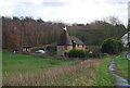
1
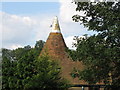
Oast House now converted, Hollingbourne
On the Ashford Road, opposite the Park Gate Inn at Hollingbourne, Kent
Image: © Dave Skinner
Taken: 25 Aug 2006
0.02 miles
3
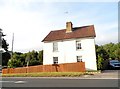
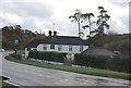
House on Ashford Road near Eyhorne Street
Image: © David Howard
Taken: 12 Jun 2016
0.02 miles
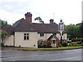
6
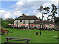
The Park Gate Inn, Hollingbourne
On the Ashford Rd, Hollingbourne, Maidstone, Kent, ME17 1PG
Image: © Dave Skinner
Taken: 25 Aug 2006
0.03 miles
7
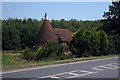
Parkgate Oast House, Ashford Road, Hollingbourne, Kent
Image: © Oast House Archive
Taken: 29 Jun 2009
0.03 miles
8
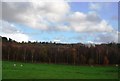
The M20 on an embankment near Leeds Castle
Image: © N Chadwick
Taken: 29 Nov 2009
0.05 miles
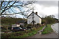
10
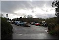
Park Gate Inn Car Park
Also the car park for Leeds Castle Golf Club
Image: © N Chadwick
Taken: 29 Nov 2009
0.06 miles