IMAGES TAKEN NEAR TO
Runham Lane, MAIDSTONE, ME17 1NH
Introduction
This page details the photographs taken nearby to Runham Lane, ME17 1NH by members of the Geograph project.
The Geograph project started in 2005 with the aim of publishing, organising and preserving representative images for every square kilometre of Great Britain, Ireland and the Isle of Man.

There are currently over 7.5m images from over14,400 individuals and you can help contribute to the project by visiting https://www.geograph.org.uk
Image Map
Images are licensed for reuse under creativecommons.org/licenses/by-sa/2.0
Notes
- Clicking on the map will re-center to the selected point.
- The higher the marker number, the further away the image location is from the centre of the postcode.
Image Listing (8 Images Found)
Images are licensed for reuse under creativecommons.org/licenses/by-sa/2.0
Image
Details
Distance
2
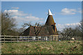
Oast House in Runhams Farm
On Runham Lane.
Image: © David Anstiss
Taken: 22 Feb 2009
0.01 miles
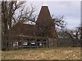
3
Runhams Farm
Runham Lane. Note; spelt on many maps as Runham Farm but is called Runhams Farm.
Image: © David Anstiss
Taken: 22 Feb 2009
0.04 miles
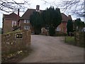
4
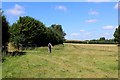
Public Footpath leading towards Fairbourne Mill
The footpath follows the hedgerow from Runham Lane
Image: © Chris Heaton
Taken: 12 Aug 2016
0.08 miles
5
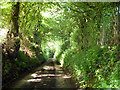
Runham Lane
Getting more and more sunken as it descends the Greensand ridge.
Image: © Robin Webster
Taken: 9 Jun 2016
0.23 miles
7
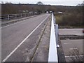
Runham Lane road bridge over M20 Motorway
Runham Lane leads to Platt's Heath from Lenham. Motorway going under bridge heads left to Ashford/Folkestone from Maidstone/M25.
Image: © David Anstiss
Taken: 22 Feb 2009
0.25 miles
8
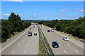
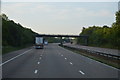
M20 near Harrietsham
Looking westwards from the bridge that carries Runham Lane over the motorway.
Image: © Chris Heaton
Taken: 12 Aug 2016
0.25 miles