IMAGES TAKEN NEAR TO
Ashford Road, MAIDSTONE, ME17 1HY
Introduction
This page details the photographs taken nearby to Ashford Road, ME17 1HY by members of the Geograph project.
The Geograph project started in 2005 with the aim of publishing, organising and preserving representative images for every square kilometre of Great Britain, Ireland and the Isle of Man.

There are currently over 7.5m images from over14,400 individuals and you can help contribute to the project by visiting https://www.geograph.org.uk
Image Map
Images are licensed for reuse under creativecommons.org/licenses/by-sa/2.0
Notes
- Clicking on the map will re-center to the selected point.
- The higher the marker number, the further away the image location is from the centre of the postcode.
Image Listing (73 Images Found)
Images are licensed for reuse under creativecommons.org/licenses/by-sa/2.0
Image
Details
Distance
2
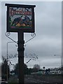
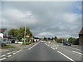
Harrietsham Village Sign
On small green at junction of West Street and A20 Ashford Road (seen on right).
Shows Pilgrims on route to Canterbury.
Image: © David Anstiss
Taken: 24 Feb 2009
0.03 miles

4
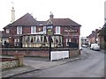
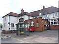
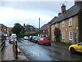
The Roebuck Public House, Harrietsham
On West Street.
Image: © David Anstiss
Taken: 24 Feb 2009
0.03 miles

10
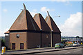
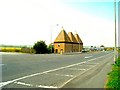
Mock Oast House at Tenacre Court, Ashford Road, Harrietsham, Kent
Image: © Oast House Archive
Taken: 23 Sep 2007
0.05 miles