IMAGES TAKEN NEAR TO
Chapmans Place, MAIDSTONE, ME17 1GB
Introduction
This page details the photographs taken nearby to Chapmans Place, ME17 1GB by members of the Geograph project.
The Geograph project started in 2005 with the aim of publishing, organising and preserving representative images for every square kilometre of Great Britain, Ireland and the Isle of Man.

There are currently over 7.5m images from over14,400 individuals and you can help contribute to the project by visiting https://www.geograph.org.uk
Image Map (Loading...)


Getting Data...Please wait
Leaflet Map data © OpenStreetMap
Images are licensed for reuse under creativecommons.org/licenses/by-sa/2.0
Notes
- Clicking on the map will re-center to the selected point.
- The higher the marker number, the further away the image location is from the centre of the postcode.
Image Listing (57 Images Found)
Images are licensed for reuse under creativecommons.org/licenses/by-sa/2.0
Image
Details
Distance

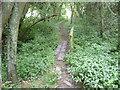
4
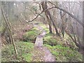
The Greensand Way goes over small footbridge
The long distance path heads from Windmill Hill road to Chart Hill Road.
It goes over small footbridge over a stream.
Image: © David Anstiss
Taken: 11 Mar 2009
0.14 miles
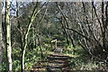
8
The Greensand Way near Ulcombe
Just east of Ulcombe Church, the Greensand Way crosses a small stream which flows from an old mill pond.
Image: © Marathon
Taken: 20 Jul 2014
0.16 miles