IMAGES TAKEN NEAR TO
Eastwood Road, MAIDSTONE, ME17 1EJ
Introduction
This page details the photographs taken nearby to Eastwood Road, ME17 1EJ by members of the Geograph project.
The Geograph project started in 2005 with the aim of publishing, organising and preserving representative images for every square kilometre of Great Britain, Ireland and the Isle of Man.

There are currently over 7.5m images from over14,400 individuals and you can help contribute to the project by visiting https://www.geograph.org.uk
Image Map
Images are licensed for reuse under creativecommons.org/licenses/by-sa/2.0
Notes
- Clicking on the map will re-center to the selected point.
- The higher the marker number, the further away the image location is from the centre of the postcode.
Image Listing (20 Images Found)
Images are licensed for reuse under creativecommons.org/licenses/by-sa/2.0
Image
Details
Distance
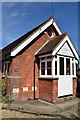
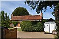
4
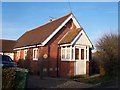
Wesley Cottage
Converted Wesley Chapel, on Eastwood Road. Has etched foundation stone near front door, which reads ' Mary Moss, Nov 20 1907'.
Image: © David Anstiss
Taken: 11 Mar 2009
0.05 miles