IMAGES TAKEN NEAR TO
Chestnut Close, MAIDSTONE, ME17 1EA
Introduction
This page details the photographs taken nearby to Chestnut Close, ME17 1EA by members of the Geograph project.
The Geograph project started in 2005 with the aim of publishing, organising and preserving representative images for every square kilometre of Great Britain, Ireland and the Isle of Man.

There are currently over 7.5m images from over14,400 individuals and you can help contribute to the project by visiting https://www.geograph.org.uk
Image Map
Images are licensed for reuse under creativecommons.org/licenses/by-sa/2.0
Notes
- Clicking on the map will re-center to the selected point.
- The higher the marker number, the further away the image location is from the centre of the postcode.
Image Listing (24 Images Found)
Images are licensed for reuse under creativecommons.org/licenses/by-sa/2.0
Image
Details
Distance
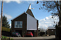
3
Ulcombe Primary School
On The Street.
Image: © Oast House Archive
Taken: 30 Mar 2009
0.07 miles
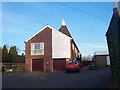
5
Oast House at Piglets, The Street, Ulcombe, Kent
Single square kilned oast house.
Image: © Oast House Archive
Taken: 30 Mar 2009
0.08 miles
7
Piglets Oast House
On The Street. Beside Speedstick Ltd.
Image: © David Anstiss
Taken: 11 Mar 2009
0.09 miles
9
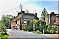
Contrast in housing on The Street - Ulcombe
Image: © Brian Chadwick
Taken: 23 Apr 2014
0.10 miles
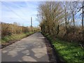
10
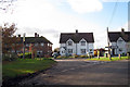
Houses at junction on Headcorn Road
Image: © Oast House Archive
Taken: 12 Nov 2008
0.11 miles