IMAGES TAKEN NEAR TO
Water Lane, MAIDSTONE, ME17 1DL
Introduction
This page details the photographs taken nearby to Water Lane, ME17 1DL by members of the Geograph project.
The Geograph project started in 2005 with the aim of publishing, organising and preserving representative images for every square kilometre of Great Britain, Ireland and the Isle of Man.

There are currently over 7.5m images from over14,400 individuals and you can help contribute to the project by visiting https://www.geograph.org.uk
Image Map
Images are licensed for reuse under creativecommons.org/licenses/by-sa/2.0
Notes
- Clicking on the map will re-center to the selected point.
- The higher the marker number, the further away the image location is from the centre of the postcode.
Image Listing (20 Images Found)
Images are licensed for reuse under creativecommons.org/licenses/by-sa/2.0
Image
Details
Distance
2
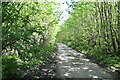
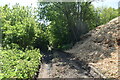
Footpath on Water Lane
Path leads in Kings Wood, then across Chegworth Road and onto Broomfield Road.
Muddy, Water Lane leads to Waterlane Cottages.
Image: © David Anstiss
Taken: 24 Feb 2009
0.05 miles
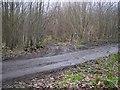
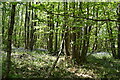
7

Path junction, Kings Wood
The public path is the less used one to the right, but they rejoin eventually, the left path being shorter.
Image: © Robin Webster
Taken: 11 Jun 2016
0.10 miles
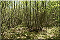
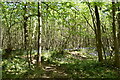
9

Coppiced area, Kings Wood
It is chestnut coppice.
Image: © Robin Webster
Taken: 11 Jun 2016
0.12 miles
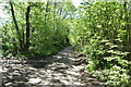
10
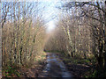
Kings Wood
On Water Lane, a dead end road which runs through the woodland.
Image: © Oast House Archive
Taken: 1 Mar 2010
0.13 miles