IMAGES TAKEN NEAR TO
Ulcombe Hill, MAIDSTONE, ME17 1DJ
Introduction
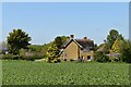
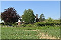
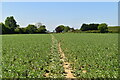
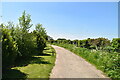
This page details the photographs taken nearby to Ulcombe Hill, ME17 1DJ by members of the Geograph project.
The Geograph project started in 2005 with the aim of publishing, organising and preserving representative images for every square kilometre of Great Britain, Ireland and the Isle of Man.

There are currently over 7.5m images from over14,400 individuals and you can help contribute to the project by visiting https://www.geograph.org.uk
Image Map
Images are licensed for reuse under creativecommons.org/licenses/by-sa/2.0
Notes
- Clicking on the map will re-center to the selected point.
- The higher the marker number, the further away the image location is from the centre of the postcode.
Image Listing (17 Images Found)
Images are licensed for reuse under creativecommons.org/licenses/by-sa/2.0
Image
Details
Distance
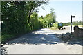
1
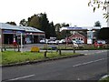
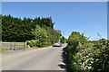
Wents Service Station
Wents is the local word for crossroads - in this case a surprisingly busy one considering it is "in the middle of nowhere". Ulcombe Hill (left), leading down to Image meets Lenham Road with Chegworth Road out of shot on the right.
Image: © Penny Mayes
Taken: 7 Nov 2005
0.01 miles