IMAGES TAKEN NEAR TO
Water Lane, MAIDSTONE, ME17 1DE
Introduction
This page details the photographs taken nearby to Water Lane, ME17 1DE by members of the Geograph project.
The Geograph project started in 2005 with the aim of publishing, organising and preserving representative images for every square kilometre of Great Britain, Ireland and the Isle of Man.

There are currently over 7.5m images from over14,400 individuals and you can help contribute to the project by visiting https://www.geograph.org.uk
Image Map
Images are licensed for reuse under creativecommons.org/licenses/by-sa/2.0
Notes
- Clicking on the map will re-center to the selected point.
- The higher the marker number, the further away the image location is from the centre of the postcode.
Image Listing (5 Images Found)
Images are licensed for reuse under creativecommons.org/licenses/by-sa/2.0
Image
Details
Distance
1
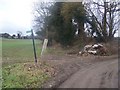
Footpath crossroads on Water lane
Water Lane named byway leads uphill from Waterlane Farm, then goes through green tunnel up to Waterlane Cottages then becomes a narrow lane. Crossing this is a footpath heading right along farm track, then across a field to Chegworth Lane, from Fairbourne Lane, near Fairbourne Manor Farm.
Image: © David Anstiss
Taken: 24 Feb 2009
0.16 miles
2
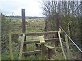
Footpath junction near Spion Kop Farm
Footpath from Cherry Gardens, leads over this stile and another leading to Polhill, near Harrietsham. Crossing this is a bridlepath on a lane from Waterlane Farm leading right to Poplar Farm.
Image: © David Anstiss
Taken: 24 Feb 2009
0.18 miles
3
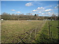
Field at Partridge Farm
The footpath runs diagonally across the horse fields towards Polhill.
Image: © Oast House Archive
Taken: 1 Mar 2010
0.21 miles
4
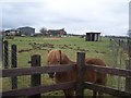
Friendly pony in Spion Kop Farm
As seen from footpath from Polhill to Waterlane Farm. Footpath between two fences through pony paddocks.
Image: © David Anstiss
Taken: 24 Feb 2009
0.22 miles
5
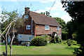
Waterlane Farm
Farming operation near Harrietsham
Image: © Chris Heaton
Taken: 12 Aug 2016
0.24 miles