IMAGES TAKEN NEAR TO
Ashford Road, MAIDSTONE, ME17 1BJ
Introduction
This page details the photographs taken nearby to Ashford Road, ME17 1BJ by members of the Geograph project.
The Geograph project started in 2005 with the aim of publishing, organising and preserving representative images for every square kilometre of Great Britain, Ireland and the Isle of Man.

There are currently over 7.5m images from over14,400 individuals and you can help contribute to the project by visiting https://www.geograph.org.uk
Image Map
Images are licensed for reuse under creativecommons.org/licenses/by-sa/2.0
Notes
- Clicking on the map will re-center to the selected point.
- The higher the marker number, the further away the image location is from the centre of the postcode.
Image Listing (12 Images Found)
Images are licensed for reuse under creativecommons.org/licenses/by-sa/2.0
Image
Details
Distance
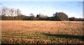
1

Dickley Wood House just south of Dickley Wood
Image: © N Chadwick
Taken: 28 Nov 2010
0.10 miles
5
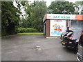
Car wash at Lenham Road Service Station
Image: © David Howard
Taken: 12 Jun 2016
0.20 miles
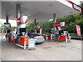
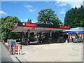
8
Petrol station on the A20
East of Harrietsham at the junction with Dickley Lane.
Image: © Penny Mayes
Taken: 31 Jan 2007
0.23 miles
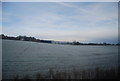
9
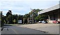
Marley Factory
Loading dock and entrance to the Marley Flooring factory which occupies a large area in the north of this square and the south of Image
Image: © Penny Mayes
Taken: 9 Oct 2005
0.23 miles
10
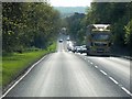
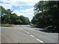
Romanian HGV on Ashford Road
Warberer's MAN HGV travelling southwards on the A20, Ashford Road near Harrietsham in Kent.
Image: © David Dixon
Taken: 16 May 2013
0.23 miles