IMAGES TAKEN NEAR TO
Church Lane, MAIDSTONE, ME17 1BA
Introduction
This page details the photographs taken nearby to Church Lane, ME17 1BA by members of the Geograph project.
The Geograph project started in 2005 with the aim of publishing, organising and preserving representative images for every square kilometre of Great Britain, Ireland and the Isle of Man.

There are currently over 7.5m images from over14,400 individuals and you can help contribute to the project by visiting https://www.geograph.org.uk
Image Map
Images are licensed for reuse under creativecommons.org/licenses/by-sa/2.0
Notes
- Clicking on the map will re-center to the selected point.
- The higher the marker number, the further away the image location is from the centre of the postcode.
Image Listing (32 Images Found)
Images are licensed for reuse under creativecommons.org/licenses/by-sa/2.0
Image
Details
Distance
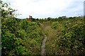
2
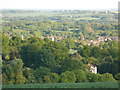
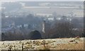
View of Harrietsham
Taken with a zoom lens from the top of a nearby hill.
Image: © Danny P Robinson
Taken: 2 Jun 2013
0.06 miles
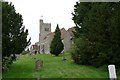
4
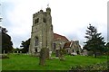
Harrietsham church
St. John the Baptist's.
Image: © Robin Webster
Taken: 8 Oct 2015
0.08 miles
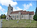
7
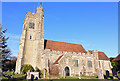
St John the Baptist, Harrietsham
Church in Harrietsham.
Image: © Wayland Smith
Taken: 3 Feb 2019
0.09 miles
8
Harrietsham church
St. John the Baptist's.
Image: © Robin Webster
Taken: 8 Oct 2015
0.09 miles
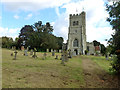
10
St John the Baptist Church, Harrietsham
Grade I listed. http://www.britishlistedbuildings.co.uk/en-173741-church-of-st-john-the-baptist-harrietsha
Image: © N Chadwick
Taken: 28 Nov 2010
0.09 miles