IMAGES TAKEN NEAR TO
Hermitage Lane, MAIDSTONE, ME16 9PH
Introduction
This page details the photographs taken nearby to Hermitage Lane, ME16 9PH by members of the Geograph project.
The Geograph project started in 2005 with the aim of publishing, organising and preserving representative images for every square kilometre of Great Britain, Ireland and the Isle of Man.

There are currently over 7.5m images from over14,400 individuals and you can help contribute to the project by visiting https://www.geograph.org.uk
Image Map
Images are licensed for reuse under creativecommons.org/licenses/by-sa/2.0
Notes
- Clicking on the map will re-center to the selected point.
- The higher the marker number, the further away the image location is from the centre of the postcode.
Image Listing (21 Images Found)
Images are licensed for reuse under creativecommons.org/licenses/by-sa/2.0
Image
Details
Distance
1
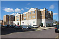
Maidstone Hospital
From the new car park around the back - I'm sure it will look better once landscaping is complete. On old maps this is shown as a Mental Hospital but it has served as Maidstone's main general hospital for some years.
Image: © Penny Mayes
Taken: 27 Jun 2005
0.07 miles


4
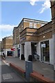
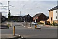
Apartments off Marigold Way
Built around 2006, the building has shops and businesses at ground floor and apartments above.
Image: © Oast House Archive
Taken: 23 Mar 2011
0.12 miles