IMAGES TAKEN NEAR TO
Springwood Road, MAIDSTONE, ME16 9PG
Introduction
This page details the photographs taken nearby to Springwood Road, ME16 9PG by members of the Geograph project.
The Geograph project started in 2005 with the aim of publishing, organising and preserving representative images for every square kilometre of Great Britain, Ireland and the Isle of Man.

There are currently over 7.5m images from over14,400 individuals and you can help contribute to the project by visiting https://www.geograph.org.uk
Image Map
Images are licensed for reuse under creativecommons.org/licenses/by-sa/2.0
Notes
- Clicking on the map will re-center to the selected point.
- The higher the marker number, the further away the image location is from the centre of the postcode.
Image Listing (63 Images Found)
Images are licensed for reuse under creativecommons.org/licenses/by-sa/2.0
Image
Details
Distance
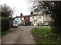
2
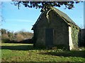
Abandoned Chapel in Abandoned Cemetery
Near Oakapple Lane. Only 1 grave left in cemetery with lots of fine old trees.
Image: © David Anstiss
Taken: 21 Jan 2009
0.05 miles

6
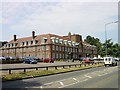
Nurses Home, Barming
Marked on the map as "Mills", this building shows a date of 1920 above the main doorways. The far end is a nurses home and the nearer end a staff education centre for the nearby Maidstone Hospital.
Image: © Penny Mayes
Taken: 27 Jun 2005
0.12 miles
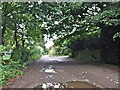
9
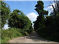
Hermitage Road, Barming
At the end of Oakapple Lane
Image: © David Howard
Taken: 19 Jun 2016
0.13 miles