IMAGES TAKEN NEAR TO
Tonbridge Road, MAIDSTONE, ME16 9HB
Introduction
This page details the photographs taken nearby to Tonbridge Road, ME16 9HB by members of the Geograph project.
The Geograph project started in 2005 with the aim of publishing, organising and preserving representative images for every square kilometre of Great Britain, Ireland and the Isle of Man.

There are currently over 7.5m images from over14,400 individuals and you can help contribute to the project by visiting https://www.geograph.org.uk
Image Map
Images are licensed for reuse under creativecommons.org/licenses/by-sa/2.0
Notes
- Clicking on the map will re-center to the selected point.
- The higher the marker number, the further away the image location is from the centre of the postcode.
Image Listing (34 Images Found)
Images are licensed for reuse under creativecommons.org/licenses/by-sa/2.0
Image
Details
Distance
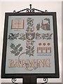
1
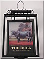
The Bull Pub Sign, Barming
On the A26 Tonbridge Road, outside Image
Image: © David Anstiss
Taken: 26 Jan 2012
0.00 miles
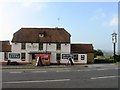
2
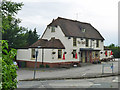
The Bull, Barming
On Tonbridge Road at the corner with South Street. An 18th century grade II listed building.
Image: © Robin Webster
Taken: 27 Jun 2012
0.01 miles
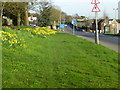
4
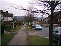
Barming Village Sign, Barming
This village sign is beside the A26 Tonbridge road heading towards Maidstone.
Barming is on the outskirts of the town.
In the background is a bus from Tonbridge heading towards Maidstone.
Image: © David Anstiss
Taken: 26 Jan 2012
0.02 miles
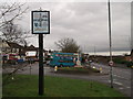
5
Barming Village Sign (Close-up)
Showing the various parts of the small village on the outskirts of Maidstone.
See also Image
Image: © David Anstiss
Taken: 26 Jan 2012
0.02 miles
6
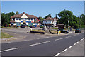
Former Trolley Bus Terminus, East Barming
At junction of North Street onto Tonbridge Road.
A 2009 view of Image
Image: © Oast House Archive
Taken: 1 Jun 2009
0.02 miles
8
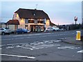
The Bull Pub, East Barming
On junction of A26 Tonbridge Road (in front) and South Street (unseen just to left of Pub). Seen from South Street on northside of A26.
Image: © David Anstiss
Taken: 26 Jan 2009
0.02 miles
9
East Barming
Looking south towards the old village centre.
Image: © Lisa Fulcher
Taken: Unknown
0.02 miles
10
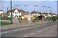
British Trolleybuses - Maidstone
This was the western terminus of the route at the Bull Inn, Barming (which is behind the photographer).
Remove the trolleybus and the overhead wires with their poles, and the view is virtually unchanged today. War memorial, corner shops, phone box, even the zebra crossing at the right are still to be seen in the current Local Live birds eye views.
For a slide show of British Trolleybuses in the late 60s http://www.geograph.org.uk/search.php?i=1773236&displayclass=slide
Image: © Alan Murray-Rust
Taken: 15 Apr 1967
0.03 miles