IMAGES TAKEN NEAR TO
Wood Court, MAIDSTONE, ME16 9DD
Introduction
This page details the photographs taken nearby to Wood Court, ME16 9DD by members of the Geograph project.
The Geograph project started in 2005 with the aim of publishing, organising and preserving representative images for every square kilometre of Great Britain, Ireland and the Isle of Man.

There are currently over 7.5m images from over14,400 individuals and you can help contribute to the project by visiting https://www.geograph.org.uk
Image Map
Images are licensed for reuse under creativecommons.org/licenses/by-sa/2.0
Notes
- Clicking on the map will re-center to the selected point.
- The higher the marker number, the further away the image location is from the centre of the postcode.
Image Listing (95 Images Found)
Images are licensed for reuse under creativecommons.org/licenses/by-sa/2.0
Image
Details
Distance
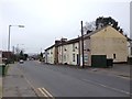
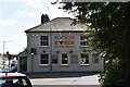
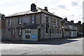
2
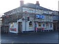
The Duke of Edinburgh Pub, Maidstone
On traffic light junction of Heath Road (on right) and Fountain Lane (on left).
Pub sign has been removed due to the scaffolding.
Update, Oct 2010, Renovations complete. Pub Sign back. See Image
Image: © David Anstiss
Taken: 21 Jan 2009
0.01 miles
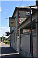
3
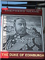
The Duke of Edinburgh, Pub Sign, Maidstone
Image: © David Anstiss
Taken: 8 Oct 2010
0.01 miles
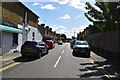
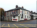
9
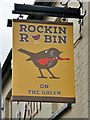
Rockin Robin sign
Formerly called the Duke of Edinburgh.
See previous sign Image
Image: © Oast House Archive
Taken: 3 Sep 2019
0.04 miles