IMAGES TAKEN NEAR TO
Woodford Road, MAIDSTONE, ME16 9BP
Introduction
This page details the photographs taken nearby to Woodford Road, ME16 9BP by members of the Geograph project.
The Geograph project started in 2005 with the aim of publishing, organising and preserving representative images for every square kilometre of Great Britain, Ireland and the Isle of Man.

There are currently over 7.5m images from over14,400 individuals and you can help contribute to the project by visiting https://www.geograph.org.uk
Image Map
Images are licensed for reuse under creativecommons.org/licenses/by-sa/2.0
Notes
- Clicking on the map will re-center to the selected point.
- The higher the marker number, the further away the image location is from the centre of the postcode.
Image Listing (59 Images Found)
Images are licensed for reuse under creativecommons.org/licenses/by-sa/2.0
Image
Details
Distance
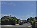
2
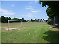
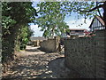
Gatland Lane Park
This small park is on the western edge of Maidstone at Barming.
Image: © Marathon
Taken: 11 Jul 2013
0.09 miles
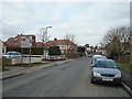
3
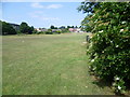
Gatland Lane Park
This small park is on the western edge of Maidstone at Barming.
Image: © Marathon
Taken: 11 Jul 2013
0.10 miles
10
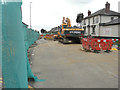
Excavator, Tonbridge Road (A26)
The machine is parked outside the Spice Fusion Indian restaurant and is being used to excavate the Image just beyond it.
The A26 was closed in both directions to through traffic between Fountain Lane traffic lights and Queen’s Road traffic lights. Traffic was diverted along Terrace Way (A20), London Road (A20), Ashton Way (A228) and Malling Road (A228) and vice versa until it reopened on Sunday 21 October 2018.
Image: © John Baker
Taken: 17 Jun 2018
0.14 miles