IMAGES TAKEN NEAR TO
Florence Road, MAIDSTONE, ME16 8EN
Introduction
This page details the photographs taken nearby to Florence Road, ME16 8EN by members of the Geograph project.
The Geograph project started in 2005 with the aim of publishing, organising and preserving representative images for every square kilometre of Great Britain, Ireland and the Isle of Man.

There are currently over 7.5m images from over14,400 individuals and you can help contribute to the project by visiting https://www.geograph.org.uk
Image Map
Images are licensed for reuse under creativecommons.org/licenses/by-sa/2.0
Notes
- Clicking on the map will re-center to the selected point.
- The higher the marker number, the further away the image location is from the centre of the postcode.
Image Listing (135 Images Found)
Images are licensed for reuse under creativecommons.org/licenses/by-sa/2.0
Image
Details
Distance

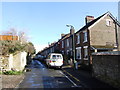
6
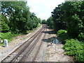
The Medway Valley Line at Bower Lane
The Medway Valley Line was built in two stages by the South Eastern Railway. The first stage, opened in 1844, was from Paddock Wood following the Medway Valley to Maidstone. In 1856 the line was extended up the Medway Valley to the North Kent Line at Strood (which had opened in 1847). Here between Maidstone West and East Farleigh is the 1844 section. This is looking in the direction of Maidstone West from the footbridge which links Wharf Road on the far side of the River Medway and the Medway Valley Walk with Bower Lane. A short line left the tracks just ahead on the right and ran on a bridge across the River Medway to a goods station at Tovil until 3rd October 1977, when the branch line closed completely.
There is additionally a foot crossing here - see http://www.geograph.org.uk/photo/3550923
Image: © Marathon
Taken: 11 Jul 2013
0.07 miles
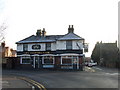
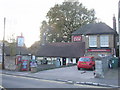
9

The Coopers Case Pub, Maidstone
On junction of Bower Lane (on right) and Lower Fant Road (going behind Pub).
Image: © David Anstiss
Taken: 21 Jan 2009
0.08 miles