IMAGES TAKEN NEAR TO
Lower Fant Road, MAIDSTONE, ME16 8DP
Introduction
This page details the photographs taken nearby to Lower Fant Road, ME16 8DP by members of the Geograph project.
The Geograph project started in 2005 with the aim of publishing, organising and preserving representative images for every square kilometre of Great Britain, Ireland and the Isle of Man.

There are currently over 7.5m images from over14,400 individuals and you can help contribute to the project by visiting https://www.geograph.org.uk
Image Map
Images are licensed for reuse under creativecommons.org/licenses/by-sa/2.0
Notes
- Clicking on the map will re-center to the selected point.
- The higher the marker number, the further away the image location is from the centre of the postcode.
Image Listing (127 Images Found)
Images are licensed for reuse under creativecommons.org/licenses/by-sa/2.0
Image
Details
Distance
3
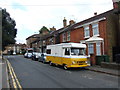
Classic Peugeot Camper Van, Upper Fant Road, Maidstone
Image: © Chris Whippet
Taken: 2 Sep 2014
0.06 miles
4

Exhaust Sculpture, Bower Lane, Maidstone
Image: © Chris Whippet
Taken: 27 Mar 2011
0.06 miles
5
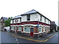
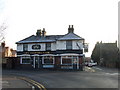
The Coopers Cask, Maidstone
This pub is now closed down, and its original name "The Ropemakers Arms" has been revealed.
Image: © Chris Whippet
Taken: 27 May 2014
0.07 miles
6

Flats on Roseholme
Overlooking the railway and the River Medway, for those living towards the top.
Image: © Robin Webster
Taken: 27 Jun 2012
0.07 miles
7
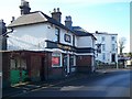
The Coopers Case Pub, Maidstone
On junction of Bower Lane (on right) and Lower Fant Road (going behind Pub).
Image: © David Anstiss
Taken: 21 Jan 2009
0.07 miles