IMAGES TAKEN NEAR TO
James Huxley Avenue, MAIDSTONE, ME16 0ZH
Introduction
This page details the photographs taken nearby to James Huxley Avenue, ME16 0ZH by members of the Geograph project.
The Geograph project started in 2005 with the aim of publishing, organising and preserving representative images for every square kilometre of Great Britain, Ireland and the Isle of Man.

There are currently over 7.5m images from over14,400 individuals and you can help contribute to the project by visiting https://www.geograph.org.uk
Image Map
Images are licensed for reuse under creativecommons.org/licenses/by-sa/2.0
Notes
- Clicking on the map will re-center to the selected point.
- The higher the marker number, the further away the image location is from the centre of the postcode.
Image Listing (101 Images Found)
Images are licensed for reuse under creativecommons.org/licenses/by-sa/2.0
Image
Details
Distance
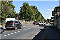
4
Fountain Lane at the junction of St Andrew's Road
Image: © David Howard
Taken: 19 Jun 2016
0.04 miles
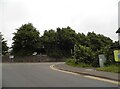
7
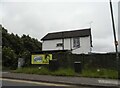
House by Fountain Lane, Barming
The front is on St Andrew's Road
Image: © David Howard
Taken: 19 Jun 2016
0.05 miles
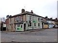
8
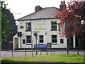
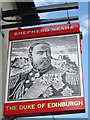
The Duke of Edinburgh, Barming
A Shepherd Neame pub on Heath Road at junction with Fountain Lane.
Image: © Oast House Archive
Taken: 21 Apr 2011
0.05 miles