IMAGES TAKEN NEAR TO
Charlock Close, MAIDSTONE, ME16 0UA
Introduction
This page details the photographs taken nearby to Charlock Close, ME16 0UA by members of the Geograph project.
The Geograph project started in 2005 with the aim of publishing, organising and preserving representative images for every square kilometre of Great Britain, Ireland and the Isle of Man.

There are currently over 7.5m images from over14,400 individuals and you can help contribute to the project by visiting https://www.geograph.org.uk
Image Map
Images are licensed for reuse under creativecommons.org/licenses/by-sa/2.0
Notes
- Clicking on the map will re-center to the selected point.
- The higher the marker number, the further away the image location is from the centre of the postcode.
Image Listing (34 Images Found)
Images are licensed for reuse under creativecommons.org/licenses/by-sa/2.0
Image
Details
Distance
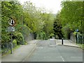
2
Castle Road Bridge over railway
Road leads to Allington Castle,from A20 London Road. Railway heads right into Maidstone from Strood.
Image: © David Anstiss
Taken: 4 Jan 2009
0.11 miles
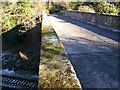
4
Footbridge over Access Road
Path leads from Little Preston to Castle Road. Access road is in Hanson Gravel Works and leads from main works on Castle road, to small area near railway.
Image: © David Anstiss
Taken: 4 Jan 2009
0.14 miles
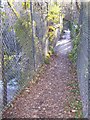
6
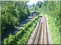
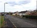
The Medway Valley Line from Castle Road
The Medway Valley Line was built in two stages by the South Eastern Railway. The first stage opened in 1844 was from Paddock Wood following the Medway Valley to Maidstone. In 1856 the line was extended up the Medway Valley to the North Kent Line at Strood (which had opened in 1847).
This view is of the 1856 section between Maidstone Barracks and Aylesford, looking in the direction of the latter. The siding and shed on the left belongs, I assume, to Allington Business Park. The view is from the bridge carrying Castle Road over the line.
Image: © Marathon
Taken: 10 Jun 2014
0.16 miles
10
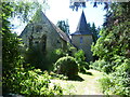
The former church of St Laurence, Allington
The church of St Laurence, Allington was rebuilt in the 19th century and the only medieval parts are the north doorway and the outer arch of the porch-tower. It is now a private dwelling called St Laurence Lodge. It has no public access and is seen here from Castle Road.
Image: © Marathon
Taken: 10 Jun 2014
0.20 miles