IMAGES TAKEN NEAR TO
London Road, MAIDSTONE, ME16 0HA
Introduction
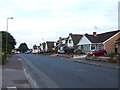
This page details the photographs taken nearby to London Road, ME16 0HA by members of the Geograph project.
The Geograph project started in 2005 with the aim of publishing, organising and preserving representative images for every square kilometre of Great Britain, Ireland and the Isle of Man.

There are currently over 7.5m images from over14,400 individuals and you can help contribute to the project by visiting https://www.geograph.org.uk
Image Map
Images are licensed for reuse under creativecommons.org/licenses/by-sa/2.0
Notes
- Clicking on the map will re-center to the selected point.
- The higher the marker number, the further away the image location is from the centre of the postcode.
Image Listing (30 Images Found)
Images are licensed for reuse under creativecommons.org/licenses/by-sa/2.0
Image
Details
Distance
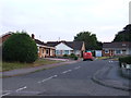
3
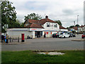
Tesco Express
At the corner of Grace Avenue and London Road, the A20.
Image: © Robin Webster
Taken: 17 Jul 2012
0.11 miles
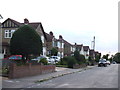
5

St Nicholas Church, Maidstone
On Poplar Grove, opposite Maple Avenue. Church with hall on left.
Image: © David Anstiss
Taken: 4 Jan 2009
0.13 miles