IMAGES TAKEN NEAR TO
St. Peters Street, MAIDSTONE, ME16 0GQ
Introduction
This page details the photographs taken nearby to St. Peters Street, ME16 0GQ by members of the Geograph project.
The Geograph project started in 2005 with the aim of publishing, organising and preserving representative images for every square kilometre of Great Britain, Ireland and the Isle of Man.

There are currently over 7.5m images from over14,400 individuals and you can help contribute to the project by visiting https://www.geograph.org.uk
Image Map
Images are licensed for reuse under creativecommons.org/licenses/by-sa/2.0
Notes
- Clicking on the map will re-center to the selected point.
- The higher the marker number, the further away the image location is from the centre of the postcode.
Image Listing (248 Images Found)
Images are licensed for reuse under creativecommons.org/licenses/by-sa/2.0
Image
Details
Distance
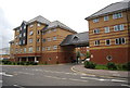
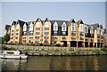
1

Pevensey Court
A new riverside development of apartments.
Image: © N Chadwick
Taken: 11 Sep 2010
0.02 miles
3
Pevensey Court
A new riverside development of apartments.
Image: © N Chadwick
Taken: 11 Sep 2010
0.03 miles
4
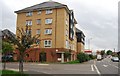
Scotney Gardens
A new riverside development of apartments.
Image: © N Chadwick
Taken: 11 Sep 2010
0.05 miles
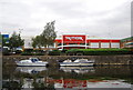
6

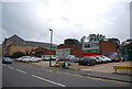
TK Maxx, St Peter's Wharf Retail Park
Riverside retail park.
Image: © N Chadwick
Taken: 11 Sep 2010
0.07 miles
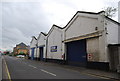
10
Raglan House, St Peter's St
A housing association property.
Image: © N Chadwick
Taken: 11 Sep 2010
0.08 miles