IMAGES TAKEN NEAR TO
Corben Close, MAIDSTONE, ME16 0FH
Introduction
This page details the photographs taken nearby to Corben Close, ME16 0FH by members of the Geograph project.
The Geograph project started in 2005 with the aim of publishing, organising and preserving representative images for every square kilometre of Great Britain, Ireland and the Isle of Man.

There are currently over 7.5m images from over14,400 individuals and you can help contribute to the project by visiting https://www.geograph.org.uk
Image Map
Images are licensed for reuse under creativecommons.org/licenses/by-sa/2.0
Notes
- Clicking on the map will re-center to the selected point.
- The higher the marker number, the further away the image location is from the centre of the postcode.
Image Listing (18 Images Found)
Images are licensed for reuse under creativecommons.org/licenses/by-sa/2.0
Image
Details
Distance
1
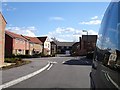
Beaver Road, Allington
A new development on the western edge of Allington.
Image: © Penny Mayes
Taken: 6 Mar 2006
0.09 miles
2
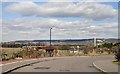
View from Beaver Road, Allington
Looking NNW towards the North Downs. A Maidstone bound train is visible behind the dutch barn and the chimney of the new Image is on the right.
Image: © Penny Mayes
Taken: 6 Mar 2006
0.09 miles


5
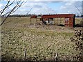
Derelict dutch barn, Allington
Looking west from the housing development built on the site of Allington Garden Centre. The line of trees marks the railway.
Image: © Penny Mayes
Taken: 6 Mar 2006
0.15 miles
6
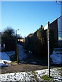
Footpath on Howard Drive
Leads down straight track to Hermitage Lane near Old Hermitage Farm.
Image: © David Anstiss
Taken: 4 Jan 2009
0.15 miles
7

Western edge of Allington
Mostly fields and pear orchards with the North Downs in the background.
Image: © Lisa Fulcher
Taken: Unknown
0.17 miles


10
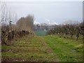
View through the orchard
Looking towards the large recycled paper mill in Image from orchards east of Hermitage Lane. The line of old poplars, planted as a windbreak have been cut down to about three foot high but are sprouting. The line of taller poplars on the left may be seen here http://www.geograph.org.uk/photo/331264 and no longer have an orchard to protect.
Image: © Penny Mayes
Taken: 5 Feb 2007
0.20 miles