IMAGES TAKEN NEAR TO
Roseleigh Avenue, MAIDSTONE, ME16 0AR
Introduction
This page details the photographs taken nearby to Roseleigh Avenue, ME16 0AR by members of the Geograph project.
The Geograph project started in 2005 with the aim of publishing, organising and preserving representative images for every square kilometre of Great Britain, Ireland and the Isle of Man.

There are currently over 7.5m images from over14,400 individuals and you can help contribute to the project by visiting https://www.geograph.org.uk
Image Map
Images are licensed for reuse under creativecommons.org/licenses/by-sa/2.0
Notes
- Clicking on the map will re-center to the selected point.
- The higher the marker number, the further away the image location is from the centre of the postcode.
Image Listing (22 Images Found)
Images are licensed for reuse under creativecommons.org/licenses/by-sa/2.0
Image
Details
Distance
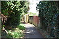
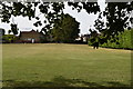
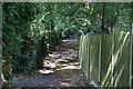
5
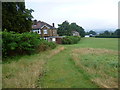
Recreation ground at the end of Hazel Avenue
This nameless recreation ground slopes down towards the Medway Valley. The end of Hazel Avenue is just ahead to the left.
Image: © Marathon
Taken: 8 Aug 2014
0.11 miles
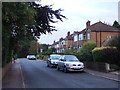
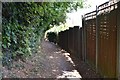
7
Hazel Avenue
Poplar Grove is at the end of the road. This in turn leads off London Road which is the A20.
Image: © Marathon
Taken: 8 Aug 2014
0.13 miles
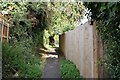
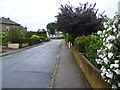
9
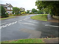
Poplar Grove
Poplar Grove leads off London Road, which is the A20. This is the junction with Hazel Avenue on the right.
Image: © Marathon
Taken: 8 Aug 2014
0.14 miles