IMAGES TAKEN NEAR TO
Target Business Centre, Bircholt Road, MAIDSTONE, ME15 9YY
Introduction
This page details the photographs taken nearby to Target Business Centre, Bircholt Road, ME15 9YY by members of the Geograph project.
The Geograph project started in 2005 with the aim of publishing, organising and preserving representative images for every square kilometre of Great Britain, Ireland and the Isle of Man.

There are currently over 7.5m images from over14,400 individuals and you can help contribute to the project by visiting https://www.geograph.org.uk
Image Map
Images are licensed for reuse under creativecommons.org/licenses/by-sa/2.0
Notes
- Clicking on the map will re-center to the selected point.
- The higher the marker number, the further away the image location is from the centre of the postcode.
Image Listing (10 Images Found)
Images are licensed for reuse under creativecommons.org/licenses/by-sa/2.0
Image
Details
Distance
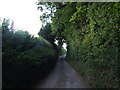
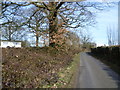
3
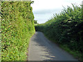
Brishing Road
A narrow high-hedged lane with a public footpath only connection just to the left of the camera with Park Wood industrial estate. This footpath (KM112) should then run parallel to the lane between the hedge on the left and the estate fence, but this route has fallen into disuse and is not practically passable. However, the lane has very light traffic.
Image: © Robin Webster
Taken: 17 Jul 2012
0.10 miles
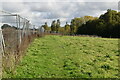
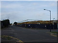
5
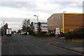
Parkwood Industrial Estate
A sprawling industrial estate on the south-east corner of Maidstone in Kent.
Image: © David Rayner
Taken: 24 Dec 2005
0.17 miles

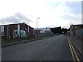
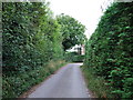
8
Brishing Road
This is the very edge of the built-up area of Maidstone. The suburb of Park Wood is to the left while the fields of Mount Pleasant Farm are to the right.
Image: © Marathon
Taken: 12 Mar 2015
0.20 miles