IMAGES TAKEN NEAR TO
Loose Road, MAIDSTONE, ME15 9UT
Introduction
This page details the photographs taken nearby to Loose Road, ME15 9UT by members of the Geograph project.
The Geograph project started in 2005 with the aim of publishing, organising and preserving representative images for every square kilometre of Great Britain, Ireland and the Isle of Man.

There are currently over 7.5m images from over14,400 individuals and you can help contribute to the project by visiting https://www.geograph.org.uk
Image Map
Images are licensed for reuse under creativecommons.org/licenses/by-sa/2.0
Notes
- Clicking on the map will re-center to the selected point.
- The higher the marker number, the further away the image location is from the centre of the postcode.
Image Listing (36 Images Found)
Images are licensed for reuse under creativecommons.org/licenses/by-sa/2.0
Image
Details
Distance
3
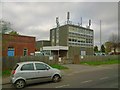
Loose Telephone Exchange, Loose Road
With a lot of aerials on the roof, presumably to do with mobile telephony and broadband.
Image: © Danny P Robinson
Taken: 5 Apr 2014
0.07 miles
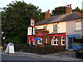
5
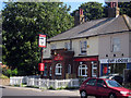
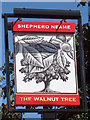
The Walnut Tree, Loose
A Shepherd Neame pub on Loose Road.
Image: © Oast House Archive
Taken: 3 Sep 2010
0.10 miles
9
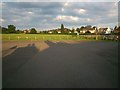
King George V Recreation Area, Loose
Image: © Danny P Robinson
Taken: 21 Jun 2014
0.12 miles